Approximate Location Map
Large Map »
Latitude: 52.4834 / 52°29'0"N
Longitude: -1.9126 / 1°54'45"W
OS Eastings: 406029
OS Northings: 287279
OS Grid: SP060872
Mapcode National: GBR 5X7.LN
Mapcode Global: VH9YW.SVQ3
Plus Code: 9C4WF3MP+9W
Entry Name: 1-7 Sloane Street
Listing Date: 5 March 2004
Grade: II
Source: Historic England
Source ID: 1408477
ID on this website: 101408477
Location: Brookfields, Birmingham, West Midlands, B1
County: Birmingham
Parish: Non Civil Parish
Built-Up Area: Birmingham
Traditional County: Warwickshire
Lieutenancy Area (Ceremonial County): West Midlands
Church of England Parish: Birmingham St Paul
Church of England Diocese: Birmingham
Tagged with: Building
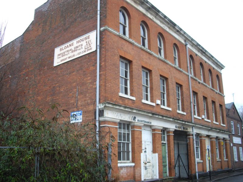
Manufactory, formerly brass foundry. c.1854, with additions of 1887 and C20 alterations. Built by David Malins, brass founder, upholsterer and ironmonger. Red brick with painted stone dressings, truncated gable stacks and a slate roof covering.
PLAN: Courtyard plan on deep rectangular plot with storeyed ranges extending to south-east and south-west sides of rear yard.
EXTERIOR: 8-bay street frontage range of 3 storeys above a basement, rising from a shallow blue brick plinth. Ground floor openings set below wide lintel band and cornice, the bays delineated by pilasters. At bays 2 and 6 are tall doorways with panelled double doors. Bay 3 has a single panelled door below a multi-pane overlight. Wide vehicle entrance to centre with C20 railed gates. Remaining bays have 8 over 8 pane sash windows in recessed panels between pilasters. First floor with 8,6 over 6 pane sashes with gauged brick heads and painted sills. Upper floor with semi-circular arch-headed openings with 2 over 2 pane sashes and a moulded sill band. Moulded eaves cornice. 3 storey attached rear range with painted ground floor and lower C20 extension which links with mid-C19 cross range at south-west end of courtyard.
HISTORY: The works, known as 'Tyndall Works' by 1886 appears to have been developed in 2 phases, with only part of the frontage range shown on the Piggot-Smith map of 1855-61, but with the rear ranges in place by this date.
SOURCE: Cattell, J Ely, S and Jones, B 2002. The Birmingham Jewellery Quarter. An Architectural Survey of the Manufactories.
A mid-C19 brass foundry site, with a little- altered street frontage range and surviving rear ranges , representing a significant branch of the metal working industries in a manufacturing quarter of Birmingham now recognised as being of international significance.
External links are from the relevant listing authority and, where applicable, Wikidata. Wikidata IDs may be related buildings as well as this specific building. If you want to add or update a link, you will need to do so by editing the Wikidata entry.


Other nearby listed buildings
