Approximate Location Map
Large Map »
Latitude: 50.2581 / 50°15'29"N
Longitude: -5.2629 / 5°15'46"W
OS Eastings: 167523
OS Northings: 44890
OS Grid: SW675448
Mapcode National: GBR Z2.0SQB
Mapcode Global: VH12B.QRKZ
Plus Code: 9C2P7P5P+7R
Entry Name: Milestone at Bridge, on south side of the B3300
Listing Date: 23 April 2012
Grade: II
Source: Historic England
Source ID: 1409062
ID on this website: 101409062
Location: Cornwall, TR16
County: Cornwall
Civil Parish: Portreath
Traditional County: Cornwall
Lieutenancy Area (Ceremonial County): Cornwall
Church of England Parish: Saint Illogan
Church of England Diocese: Truro
Tagged with: Milestone
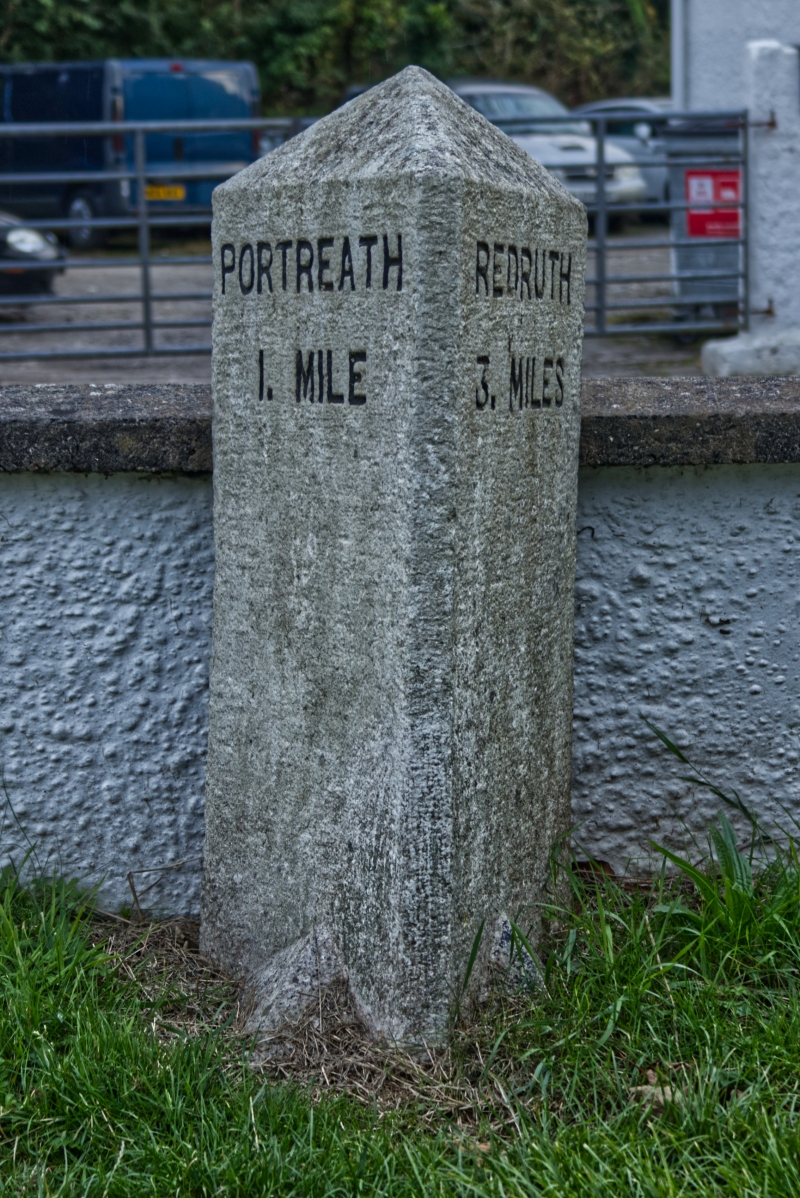
Granite milestone, thought to date from 1890, on the B3300 between Redruth and Portreath.
Milestone, thought to date from 1890, forming part of a series of three marking the distance between Redruth and Portreath on the B3300.
The milestone is made of granite and is triangular on plan, with a pyramidal top. It stands on a rectangular base, with pyramid stops to the base of each face. The milestone is painted white with the inscriptions picked out in black. The inscription on the eastern face of the milestone reads 'PORTREATH / 1. MILE' and the inscription on the western face reads 'REDRUTH / 3. MILES'.
The town of Redruth saw significant growth during the C19 through its situation at the heart of a rich site for the mining of tin and copper, and Portreath, on the coast to the north-west, was developed as one of Cornwall's pre-eminent mineral ports. A railway was built between Carn Brea (to the south-west of Redruth) and Portreath in 1837, but there was no rail link between Redruth and Portreath. The New Portreath Road (now the B3300), leading from Redruth to Portreath, was established at some time between 1880 and 1890, offering an alternative to the Old Portreath Road, which took a more southerly route. In 1890 a number of roads were adopted by Cornwall County Council as main roads, the New Portreath Road being one of these. It was a requirement that before adoption as a main road milestones should be put in place, so the three milestones marking the four-mile distance between Redruth and Portreath may have been erected immediately before the handover. All three survive.
The milestone on the B3300 at Mitchell's Garage, Bridge is listed at Grade II for the following principal reasons:
* Historical: the milestone is of note as part of a group of milestones marking a historic route between the mineral centre of Redruth and the port at Portreath
* Intactness: as a complete example of a late-C19 milestone in its original position, triangular in plan, with a clear inscription
* Group Value: with the other two listed milestones in this complete series
External links are from the relevant listing authority and, where applicable, Wikidata. Wikidata IDs may be related buildings as well as this specific building. If you want to add or update a link, you will need to do so by editing the Wikidata entry.


Other nearby listed buildings
