Approximate Location Map
Large Map »
Latitude: 50.2321 / 50°13'55"N
Longitude: -5.2331 / 5°13'59"W
OS Eastings: 169524
OS Northings: 41899
OS Grid: SW695418
Mapcode National: GBR Z3.DGFR
Mapcode Global: VH12K.7FVF
Plus Code: 9C2P6QJ8+RQ
Entry Name: Milestone situated on the southern side of the B3293, set into a gap in the forecourt wall of 32 West End, Redruth
Listing Date: 9 July 2012
Grade: II
Source: Historic England
Source ID: 1409467
ID on this website: 101409467
Location: Plain-an-Gwarry, Cornwall, TR15
County: Cornwall
Civil Parish: Redruth
Built-Up Area: Redruth
Traditional County: Cornwall
Lieutenancy Area (Ceremonial County): Cornwall
Church of England Parish: Redruth
Church of England Diocese: Truro
Tagged with: Milestone
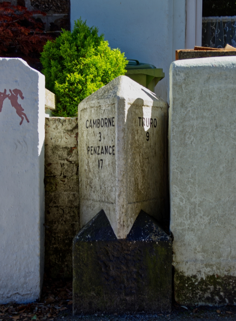
Milestone of mid-C19 date
A dressed and painted granite milestone on the south side of the B3293, set within a gap in the forecourt wall of No.32, West End, Redruth. The base is square with pyramidal stops to a triangular shaft with a pyramidal cap. The faces of the shaft have recessed rectangular panels, the west panel carries the inscription TRURO / 9 and the east panel is inscribed CAMBORNE / 3 / PENZANCE / 17. The recessed panels are a consequence of reworking by the turnpike trust and this milestone is one of two treated in this manner. The square base is painted black, while the triangular shaft is painted white and the inscribed letters are picked out in black.
The opening of the Hayle Causeway in 1825 brought about a desire to develop a new turnpike to link Redruth with Hayle to improve transport and trading opportunities for the mines in the area. An Act (“Vc.12) enabling the construction of a turnpike along the route was passed on 14th May 1839. Carved granite milestones were erected along the turnpike from Redruth, through Camborne to the Hayle Causeway, and thence to Penzance along the current route of the A30. All of these milestones were of a similar size and style, with lettering cut flush into the face of the stone. Over the years, these stones suffered some attritional damage requiring the turnpike trust to re-inscribe the lettering. Two milestones, including this stone, have needed recessed panels to be cut into the faces to allow a degree of protection to new larger inscriptions; the other example is situated two miles to the west of this example on the south side of Trevenson Road (A3047), Pool, Carn Brea (NGR SW 66391 41305).
The milestone situated on the southern side of the B3293, set into a gap in the forecourt wall of 32 West End, Redruth is designated at Grade II for the following reasons:
* Intactness: as an intact milestone associated with the Redruth to Hayle turnpike (1839) which remains in its original position;
* Historic Interest: the milestone was erected when there was an increase in freight traffic associated with the growing mining industry in this area;
* Group Value: it forms a group with other surviving milestones along the Redruth to Hayle turnpike.
External links are from the relevant listing authority and, where applicable, Wikidata. Wikidata IDs may be related buildings as well as this specific building. If you want to add or update a link, you will need to do so by editing the Wikidata entry.


Other nearby listed buildings
