Approximate Location Map
Large Map »
Latitude: 51.0395 / 51°2'22"N
Longitude: -1.5385 / 1°32'18"W
OS Eastings: 432450
OS Northings: 126780
OS Grid: SU324267
Mapcode National: GBR 74M.MWB
Mapcode Global: FRA 76NC.QFB
Plus Code: 9C3W2FQ6+QH
Entry Name: The Smithy
Listing Date: 11 April 1986
Grade: II
Source: Historic England
Source ID: 1339146
English Heritage Legacy ID: 140973
ID on this website: 101339146
Location: Mottisfont, Test Valley, Hampshire, SO51
County: Hampshire
District: Test Valley
Civil Parish: Mottisfont
Traditional County: Hampshire
Lieutenancy Area (Ceremonial County): Hampshire
Church of England Parish: Mottisfont St Andrew
Church of England Diocese: Winchester
Tagged with: Smithy
MOTTISFONT MOTTISFONT
SU 3226
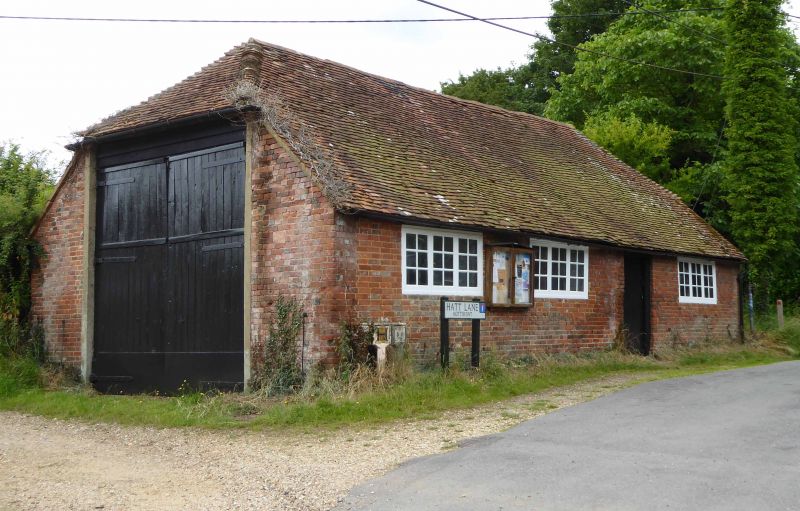
12/22 The Smithy
GV II
Smithy, now garage. C18 and C19. Brick, old plain tile roof. Single storey,
3 bay, low walls. Double doors in end. Door in centre bay, 3-light casement
in each bay. Roof half-hipped.
Listing NGR: SU3283026765
External links are from the relevant listing authority and, where applicable, Wikidata. Wikidata IDs may be related buildings as well as this specific building. If you want to add or update a link, you will need to do so by editing the Wikidata entry.


Other nearby listed buildings
