Approximate Location Map
Large Map »
Latitude: 51.0404 / 51°2'25"N
Longitude: -1.5395 / 1°32'22"W
OS Eastings: 432382
OS Northings: 126887
OS Grid: SU323268
Mapcode National: GBR 74M.MM9
Mapcode Global: FRA 76NC.J1X
Plus Code: 9C3W2FR6+56
Entry Name: Barn 20 Metres South West of Dairy Cottage
Listing Date: 11 April 1986
Grade: II
Source: Historic England
Source ID: 1093697
English Heritage Legacy ID: 141003
ID on this website: 101093697
Location: Mottisfont, Test Valley, Hampshire, SO51
County: Hampshire
District: Test Valley
Civil Parish: Mottisfont
Traditional County: Hampshire
Lieutenancy Area (Ceremonial County): Hampshire
Church of England Parish: Mottisfont St Andrew
Church of England Diocese: Winchester
Tagged with: Barn
MOTTISFONT OAKLEY ROAD
SU 3226
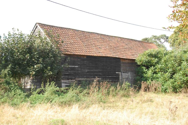
12/20 Barn 20m SW of Dairy
Cottage
GV II
Earn. C18. Timber-frame weatherboarded on brick plinth, pantile roof. 7 bay barn
with central double doors. Inside queen strut roof.
Listing NGR: SU3201227629
External links are from the relevant listing authority and, where applicable, Wikidata. Wikidata IDs may be related buildings as well as this specific building. If you want to add or update a link, you will need to do so by editing the Wikidata entry.


Other nearby listed buildings
