Approximate Location Map
Large Map »
Latitude: 51.0043 / 51°0'15"N
Longitude: -0.9383 / 0°56'17"W
OS Eastings: 474589
OS Northings: 123299
OS Grid: SU745232
Mapcode National: GBR CC3.X67
Mapcode Global: FRA 86XG.B8P
Plus Code: 9C3X2336+PM
Entry Name: 1, Chapel Street
Listing Date: 29 July 1949
Grade: II
Source: Historic England
Source ID: 1339224
English Heritage Legacy ID: 141304
ID on this website: 101339224
Location: Petersfield, East Hampshire, GU32
County: Hampshire
District: East Hampshire
Civil Parish: Petersfield
Built-Up Area: Petersfield
Traditional County: Hampshire
Lieutenancy Area (Ceremonial County): Hampshire
Church of England Parish: Petersfield St Peter
Church of England Diocese: Portsmouth
Tagged with: Building
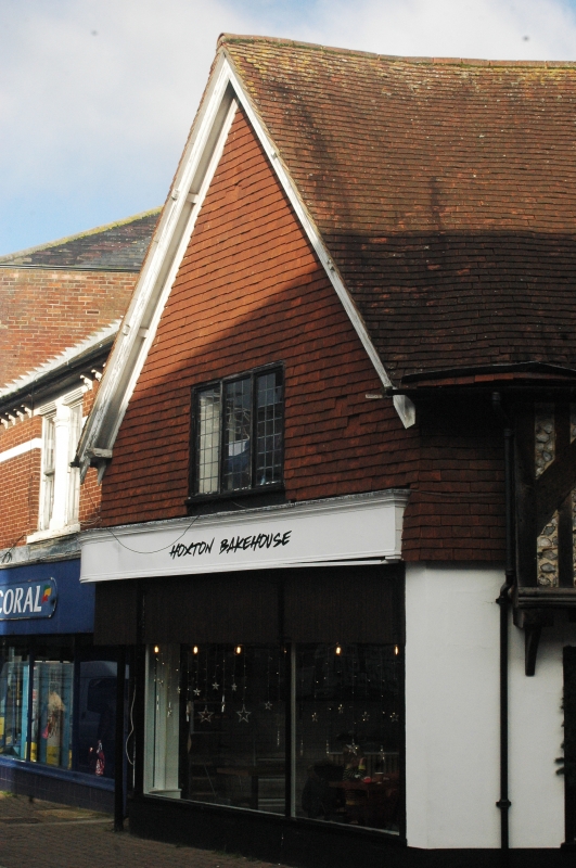
CHAPEL STREET
1.
1501
(Last Side)
No 1
SU 7423 3/2 29.7.49.
II GV
2.
Mainly C16. Continuous with No 1. The square, and graded with it. High
pitched tiled roof with tile-hung gable end on Chapel street, Close-set
timbers with flint filling on lst floor. Modern shop front on ground floor.
NMR.
Forms a group with Nos 1, 2, 3 and No 5, The Square.
Listing NGR: SU7459523298
External links are from the relevant listing authority and, where applicable, Wikidata. Wikidata IDs may be related buildings as well as this specific building. If you want to add or update a link, you will need to do so by editing the Wikidata entry.


Other nearby listed buildings
