Approximate Location Map
Large Map »
Latitude: 51.003 / 51°0'10"N
Longitude: -0.9356 / 0°56'8"W
OS Eastings: 474779
OS Northings: 123158
OS Grid: SU747231
Mapcode National: GBR CC9.47Y
Mapcode Global: FRA 86XG.K98
Plus Code: 9C3X2337+5Q
Entry Name: 12, St Peter's Road
Listing Date: 19 February 1973
Grade: II
Source: Historic England
Source ID: 1339215
English Heritage Legacy ID: 141364
ID on this website: 101339215
Location: Petersfield, East Hampshire, GU32
County: Hampshire
District: East Hampshire
Civil Parish: Petersfield
Built-Up Area: Petersfield
Traditional County: Hampshire
Lieutenancy Area (Ceremonial County): Hampshire
Church of England Parish: Petersfield St Peter
Church of England Diocese: Portsmouth
Tagged with: Building
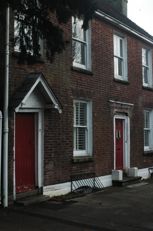
ST PETER'S ROAD
1.
1501
---------------
No 12
SU 7423 3/73
II
2.
C18 red brick cottage of 2 storeys, 4 windows. Hipped, tiled roof. Renewed
sash windows. 1 door at left of 6 fielded columns under new gabled hood.
Main door, of 4 fielded and 2 glazed panels, in simple wooden doorcase
of order with round attached columns.
Listing NGR: SU7478223158
External links are from the relevant listing authority and, where applicable, Wikidata. Wikidata IDs may be related buildings as well as this specific building. If you want to add or update a link, you will need to do so by editing the Wikidata entry.


Other nearby listed buildings
