Approximate Location Map
Large Map »
Latitude: 54.7469 / 54°44'48"N
Longitude: -3.0548 / 3°3'17"W
OS Eastings: 332197
OS Northings: 539617
OS Grid: NY321396
Mapcode National: GBR 7F3K.F4
Mapcode Global: WH80M.1YLB
Plus Code: 9C6RPWWW+Q3
Entry Name: Field Barn
Listing Date: 13 September 2013
Grade: II
Source: Historic England
Source ID: 1416127
ID on this website: 101416127
Location: Caldbeck, Cumberland, Cumbria, CA7
County: Cumbria
District: Allerdale
Civil Parish: Caldbeck
Traditional County: Cumberland
Lieutenancy Area (Ceremonial County): Cumbria
Church of England Parish: Caldbeck St Mungo
Church of England Diocese: Carlisle
Tagged with: Barn
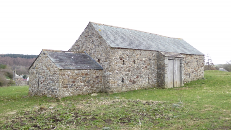
Field barn, C17 or C18 with attached feed store of c. early C19 date.
Materials: limestone rubble with Lakeland slate roofs laid in diminishing courses, and sandstone slates to the pentice roof.
Plan: rectangular oriented north west to south east with a pentice roof to the centre of the north west elevation; small and narrower single storey extension attached to north west gable.
Exterior: the barn is situated in a low lying meadow set into ground that slopes down very gently from south east to north west. The north east elevation has some quoins and a tall centrally placed entrance formed of large irregular quoins with a substantial chamfered lintel; it has an original threshold and the boarded door is a recent replacement. To either side of the central door there are groups of four narrow ventilation slits to both ground and first floors. The attached feed store to the right has a pitched roof and a large opening to the left end, fitted with a modern replacement boarded door. The south west elevation has a centrally placed entrance and pentice roof with ventilation slits to either side at ground and first floor level. The south east gable has a second entrance formed of large and irregular quoins and a segmental head set in a triangular lintel.
Interior: open and plain. There are timber lintels to both doorways and an historic roof structure remains in place; the latter comprises four pegged trusses, double purlins and a ridge piece; the timbers forming the trusses appear to have been re-used.
Field barns were generally built in areas where farmsteads and fields were sited at a distance from each other and in upland hay meadows. This example falls within an area characterised by cattle rearing from the C17 onwards and, although other working buildings in the region usually date from after the middle of the C18, many field barns here are considered to date from the later C17. This example may incorporate fragments from an earlier building. The barn is depicted on the 1:2500 Ordnance Survey map published in 1863, along with the attached, later feed store and both have an unchanged footprint to the present day.
The barn and attached feed store have recently undergone a programme of restoration; numerous holes and cracks in the barn fabric were repaired, and the attached store had one wall rebuilt and was re-roofed.
This field barn of late C17 or early C18 date, with attached later feed store, is listed at Grade II for the following principal reasons:
* Significant original fabric: an intact field barn, pierced by original openings, which clearly illustrates its original form and function;
* Date: as a field barn considered to date from late C17 or C18, it sits firmly in the period when there is a presumption that all buildings that are generally intact are listed;
* Regional diversity and character: a farm building type characteristic of the inaccessible parts of the Pennines and Lake District which illustrates the diversity of past farming practice in England.
External links are from the relevant listing authority and, where applicable, Wikidata. Wikidata IDs may be related buildings as well as this specific building. If you want to add or update a link, you will need to do so by editing the Wikidata entry.


Other nearby listed buildings
