Approximate Location Map
Large Map »
Latitude: 50.9307 / 50°55'50"N
Longitude: -2.6462 / 2°38'46"W
OS Eastings: 354684
OS Northings: 114780
OS Grid: ST546147
Mapcode National: GBR MN.PPDL
Mapcode Global: FRA 56BN.4X7
Plus Code: 9C2VW9J3+7G
Entry Name: Milestone in boundary wall
Listing Date: 24 January 2014
Grade: II
Source: Historic England
Source ID: 1417784
ID on this website: 101417784
Location: Somerset, BA20
County: Somerset
District: South Somerset
Civil Parish: Yeovil
Built-Up Area: Yeovil
Traditional County: Somerset
Lieutenancy Area (Ceremonial County): Somerset
Tagged with: Milestone
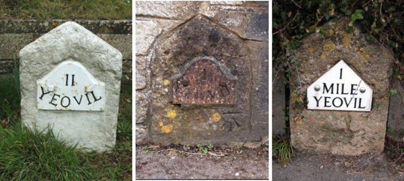
Milestone. Probably C18. It is set within a C20 boundary wall which is excluded from the listing.
Milestone. Probably C18, set within a C20 boundary wall.
MATERIALS: Hamstone with cast-iron plate.
DESCRIPTION: stone upright incorporated into a C20 boundary wall on the south side of West Coker Road. It has a shouldered triangular top; the point is rounded. The north face has an cast-iron plate with a shouldered, curved top and is inscribed: 'I / YEOVIL'.
Pursuant to s. 1 (5A) of the Planning (Listed Buildings and Conservation Areas) Act 1990 ('the Act') it is declared that the C20 boundary wall is not of special architectural or historic interest.
The first Act of Parliament to establish a turnpike trust in Somerset was in 1707-08 for roads around Bath. Bristol came next in 1731, and during the second half of the century nearly all the towns of Somerset established their trusts by Act of Parliament. The main post road through Yeovil was included in the 1753 Act, turnpiking the road from Lower Compton, to the east of Sherborne, through Chard to Axminster. The Yeovil Turnpike Trust maintained the road between Crewkerne and Yeovil between 1753 and 1849.
The milestone within the boundary wall to 31 West Coker Road is marked on the first edition Ordnance Survey map of 1887 as 'Crewkerne 8, Yeovil 1'. It is one of a set of eight milestones, of which seven are known to survive, which were erected along the principal route (A30) between Crewkerne and Yeovil, possibly in the C18.
The milestone within the boundary wall of 31 West Coker Road, Yeovil, probably of C18 date, is listed at Grade II for the following principal reasons:
* Intactness: as an intact milestone which remains in its original position;
* Historic Interest: it testifies to the great wave of C18 road improvement;
* Group value: it is part of a well-defined turnpike route between Crewkerne and Yeovil and forms a group with six other surviving milestones on this road.
External links are from the relevant listing authority and, where applicable, Wikidata. Wikidata IDs may be related buildings as well as this specific building. If you want to add or update a link, you will need to do so by editing the Wikidata entry.


Other nearby listed buildings
