Approximate Location Map
Large Map »
Latitude: 51.1494 / 51°8'57"N
Longitude: -0.9745 / 0°58'28"W
OS Eastings: 471825
OS Northings: 139408
OS Grid: SU718394
Mapcode National: GBR C9B.SK9
Mapcode Global: VHDYC.2C5P
Plus Code: 9C3X42XG+Q6
Entry Name: 15, High Street
Listing Date: 31 March 1977
Grade: II
Source: Historic England
Source ID: 1094187
English Heritage Legacy ID: 141786
ID on this website: 101094187
Location: Alton, East Hampshire, GU34
County: Hampshire
District: East Hampshire
Civil Parish: Alton
Built-Up Area: Alton
Traditional County: Hampshire
Lieutenancy Area (Ceremonial County): Hampshire
Church of England Parish: The Resurrection Alton
Church of England Diocese: Winchester
Tagged with: Building
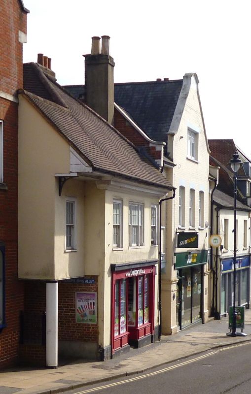
HIGH STREET
1.
5236
(South East Side)
No 15
SU 7139 2/21
II
2.
C18. Altered. 2 storeys; 3 bays wide. Stucco; tiled roof. Ground floor with
modern shop front and door set back a little on the left. 1st floor with 2 flush
sash windows and a blank window.
Listing NGR: SU7182839404
External links are from the relevant listing authority and, where applicable, Wikidata. Wikidata IDs may be related buildings as well as this specific building. If you want to add or update a link, you will need to do so by editing the Wikidata entry.


Other nearby listed buildings
