Approximate Location Map
Large Map »
Latitude: 51.4814 / 51°28'53"N
Longitude: -2.5156 / 2°30'56"W
OS Eastings: 364292
OS Northings: 175953
OS Grid: ST642759
Mapcode National: GBR CT7.TT
Mapcode Global: VH88P.B1Z5
Plus Code: 9C3VFFJM+HQ
Entry Name: Boundary marker located at the junction of Thicket Road and High Street
Listing Date: 27 March 2014
Grade: II
Source: Historic England
Source ID: 1418104
ID on this website: 101418104
Location: Staple Hill, Bristol, BS16
County: City of Bristol
Electoral Ward/Division: Frome Vale
Parish: Non Civil Parish
Built-Up Area: Bristol
Traditional County: Gloucestershire
Lieutenancy Area (Ceremonial County): Bristol
Church of England Parish: Fishponds St Mary
Church of England Diocese: Bristol
Tagged with: Boundary marker
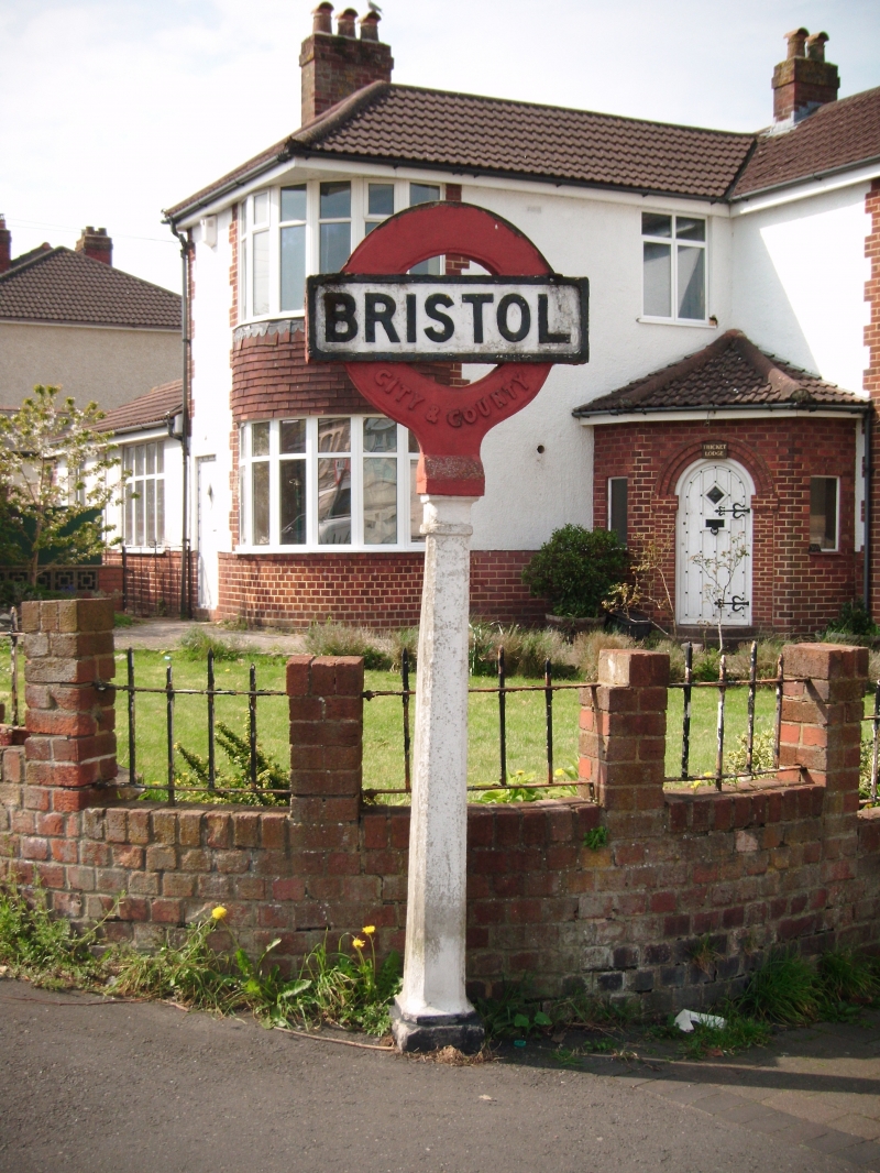
A mid-C20 county boundary marker.
MATERIALS: constructed of pre-cast concrete.
DETAILS: the boundary marker employs the stylised design of a bar and circle similar to that employed by London Transport. It comprises a tapered square post with faceted corners set on a square stone plinth. The post is painted white and the plinth is painted black. The post is surmounted by a red circle which is recessed to its outer and inner rings and has ‘CITY & COUNTY’ in raised lettering to its lower section. Across the centre of the circle is a horizontal bar, painted white, with a raised black border and ‘BRISTOL’ in raised black lettering to the centre.
Boundary markers including placed boulders or standing stones, trees and other natural landscape features were used from antiquity to indicate the bounds of land units, and any attached jurisdiction, including estates, manors, townships and parishes. Later on, carved and cast examples were introduced, which were set in a wall, incorporated in a bollard, or free-standing, and often displaying the name or initial of the territory.
The boundary marker located at the junction of Thicket Road and High Street in Staple Hill, Bristol marks the boundary between the city of Bristol and the county of Gloucestershire and appears, from map evidence, to have been erected at some point between 1951 and 1966. It now marks the boundary between Bristol and the district of South Gloucestershire which became a unitary authority in 1996, although it continues to form part of the ceremonial county of Gloucestershire.
The boundary marker at the junction of Thicket Road and High Street, Staple Hill, Bristol, erected between 1951 and 1966, is designated at Grade II for the following principal reasons:
* Historic interest: it marks the boundary between the city of Bristol and the ceremonial county of Gloucestershire;
* Intactness: in its original location, this stone boundary marker survives intact;
* Rarity: it is an unusual example of a pre-cast concrete boundary marker which employs the stylised design of a bar and circle.
External links are from the relevant listing authority and, where applicable, Wikidata. Wikidata IDs may be related buildings as well as this specific building. If you want to add or update a link, you will need to do so by editing the Wikidata entry.


Other nearby listed buildings
