Approximate Location Map
Large Map »
Latitude: 51.1503 / 51°9'1"N
Longitude: -0.9731 / 0°58'22"W
OS Eastings: 471924
OS Northings: 139509
OS Grid: SU719395
Mapcode National: GBR C9B.SYW
Mapcode Global: VHDYC.2CY0
Plus Code: 9C3X522G+4Q
Entry Name: 5, Normandy Street
Listing Date: 31 March 1977
Grade: II
Source: Historic England
Source ID: 1179990
English Heritage Legacy ID: 141875
ID on this website: 101179990
Location: Alton, East Hampshire, GU34
County: Hampshire
District: East Hampshire
Civil Parish: Alton
Built-Up Area: Alton
Traditional County: Hampshire
Lieutenancy Area (Ceremonial County): Hampshire
Church of England Parish: The Resurrection Alton
Church of England Diocese: Winchester
Tagged with: Building
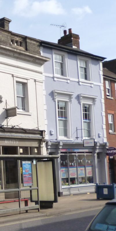
NORMANDY STREET
1.
5236
(South East Side)
No 5
SU 7139 2/96
II
2.
Mid-C19. 3 storeys; 2 bays with quoins left and right. Stucco; slate roof. Ground
floor with contemporary shop front with, left and right, entrances to the shop
and the domestic accommodation above. 1st floor windows in moulded surrounds
and with bracketted cornices. 2nd floor windows in moulded surrounds.
Listing NGR: SU7193139505
External links are from the relevant listing authority and, where applicable, Wikidata. Wikidata IDs may be related buildings as well as this specific building. If you want to add or update a link, you will need to do so by editing the Wikidata entry.


Other nearby listed buildings
