Approximate Location Map
Large Map »
Latitude: 51.1106 / 51°6'38"N
Longitude: -0.9858 / 0°59'8"W
OS Eastings: 471094
OS Northings: 135076
OS Grid: SU710350
Mapcode National: GBR B8K.9L5
Mapcode Global: VHDYJ.VBQZ
Plus Code: 9C3X4267+6M
Entry Name: Hawthorn Cottage
Listing Date: 11 October 1985
Grade: II
Source: Historic England
Source ID: 1093951
English Heritage Legacy ID: 142343
ID on this website: 101093951
Location: Upper Farringdon, East Hampshire, GU34
County: Hampshire
District: East Hampshire
Civil Parish: Farringdon
Built-Up Area: Upper Farringdon
Traditional County: Hampshire
Lieutenancy Area (Ceremonial County): Hampshire
Church of England Parish: Farringdon All Saints
Church of England Diocese: Winchester
Tagged with: Cottage
SU 73 NW FARRINGDON UPPER FARRINGDON
2/56 Hawthorn Cottage
GV II
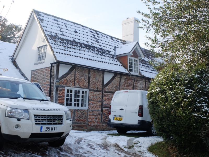
House. Early C16, early C17, early C19, with C20 restoration and minor extension.
Mainly brick walls, and a pantile roof. Late medieval 3-bay timber frame with
central hall, with insertion of chimney and upper floor (to the hall) and with an
early C19 extension and some recladding. North front: 1 storey and attic;
2 above 3 windows. The frame is exposed at the east side, with (C20) herring-
bone infill, the west side being brick work of Flemish bond with blue headers
(partly masking the 3rd bay of the frame), cambered arches to the groudfloor,
plinth. Pantile roof, with lowest courses tiled, ½-hipped at the west end,
gabled dormers with cills at eaves level. Casements. Early C20 brick porch
with gabled roof, glazed front above a 6-panelled door. At the rear the roof
extends to a lower eaves, and there is a wing of the east side, brick walls of
English and Flemish bonds. At the west end is a small C20 outshot, of tile and
brick. Inside, the framework is exposed, and indicates the sequence of changes;
there is a lobby entrance at one side of the chimney breast, and a dog-leg
staircase at the other.
Listing NGR: SU7109435076
External links are from the relevant listing authority and, where applicable, Wikidata. Wikidata IDs may be related buildings as well as this specific building. If you want to add or update a link, you will need to do so by editing the Wikidata entry.


Other nearby listed buildings
