Approximate Location Map
Large Map »
Latitude: 51.0833 / 51°4'59"N
Longitude: -1.0775 / 1°4'39"W
OS Eastings: 464711
OS Northings: 131955
OS Grid: SU647319
Mapcode National: GBR B8T.4D4
Mapcode Global: FRA 86M8.422
Plus Code: 9C3W3WMC+8X
Entry Name: Town Street Farmhouse
Listing Date: 11 October 1985
Grade: II
Source: Historic England
Source ID: 1093933
English Heritage Legacy ID: 142389
ID on this website: 101093933
Location: Ropley, East Hampshire, SO24
County: Hampshire
District: East Hampshire
Civil Parish: Ropley
Built-Up Area: Ropley
Traditional County: Hampshire
Lieutenancy Area (Ceremonial County): Hampshire
Church of England Parish: Ropley St Peter
Church of England Diocese: Winchester
Tagged with: Farmhouse
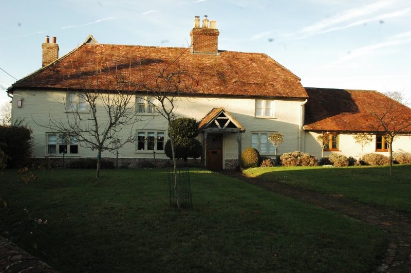
SU 63 SW ROPLEY CHURCH STREET
3/28 Town Street Farmhouse
GV II
House, linked to a former cartshed (now garages). C16, C17, early C19 and C20.
Walls of painted brickwork in English Garden Wall bond, cambered ground-floor
openings, plinth; the rear has exposed framework with brick infill, the C18
wing being of painted brickwork in Flemish bond, with exposed frame in the ½-
hipped gable. ½-hipped and hipped tile roof. A late-medieval timber framed
3-bay house, with central hall (and smoke bay) with inserted chimney and 1st
floor, C18 rear wing at the west side, and early C20 extension at the east end.
South front of 2 storeys, 3 windows, with east extension of 1 storey and attic,
1 window. Casements. Plain doorway within an open rustic gabled porch. A
short C20 single-storeyed service block links the rear wing to a former cartshed,
which has a ½-hipped tile roof, brick dentil eaves, outer walls of brickwork in
FLemish bond, the inner face of five bays now 5 garage openings.
Listing NGR: SU6447031967
External links are from the relevant listing authority and, where applicable, Wikidata. Wikidata IDs may be related buildings as well as this specific building. If you want to add or update a link, you will need to do so by editing the Wikidata entry.


Other nearby listed buildings
