Approximate Location Map
Large Map »
Latitude: 53.5291 / 53°31'44"N
Longitude: -1.1532 / 1°9'11"W
OS Eastings: 456231
OS Northings: 403936
OS Grid: SE562039
Mapcode National: GBR NWDM.4N
Mapcode Global: WHDD2.8K3D
Plus Code: 9C5WGRHW+JP
Entry Name: Former Church of St Edmund and Youth Centre, Anchorage Lane, Sprotbrough
Listing Date: 26 February 2015
Grade: II
Source: Historic England
Source ID: 1425243
ID on this website: 101425243
Location: Bentley Rise, Doncaster, South Yorkshire, DN5
County: Doncaster
Civil Parish: Sprotbrough and Cusworth
Built-Up Area: Doncaster
Traditional County: Yorkshire
Lieutenancy Area (Ceremonial County): South Yorkshire
Church of England Parish: Sprotbrough St Mary the Virgin
Church of England Diocese: Sheffield
Tagged with: Church building
Church and youth centre, formerly barn and agricultural building. C17 or C18 in origin, 1954 conversion by George Pace. 1963 extension. Magnesian limestone, buff and red brick, red pantile roof.
Church and youth centre, formerly barn and agricultural building. C17 or C18 in origin, 1954 conversion by George Pace. 1963 extension. Magnesian limestone, buff and red brick, red pantile roof.
PLAN: linear, double-height building running east-west. Church at west end in former barn. Single-storey extension with meeting room and vestry opening off north side. Entrance lobby at east end of church with west doorway into church and short corridor to youth centre (later community hall) at east end. Youth centre has small stage at west end of hall. Doorway to enclosed steps built against exterior of north wall leading up to first-floor room over entrance lobby; w.c. beneath steps accessible off entrance lobby. Modern lean-to against east gable wall of youth centre housing kitchen and w.c.
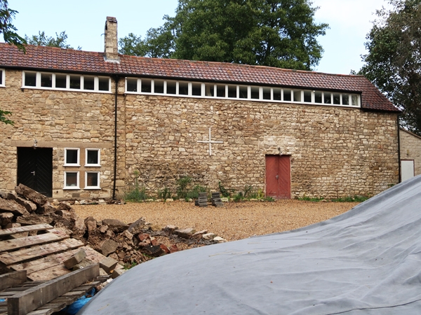
EXTERIOR: the double-height range faces south towards Anchorage Lane. It is built of roughly coursed magnesian limestone rubble and comprises two contiguous buildings of similar size with rough quoining to the left-hand corner and a straight joint at approximately midpoint. The right-hand, east, building projects forward very slightly at this point. The buildings share a double-pitched roof of red pantiles with a continuous ridgeline. The church is housed in the left-hand, west building, formerly a barn. At the apex of the west gable is a simple stone cross with a small, stone bellcote to the ridge just to the left of the straight joint. Part of the front wall has been raised at eaves level along the length of the range to form flat-roofed dormers with rows of square clerestory window lights with timber frames. At the left-hand end of the church is a dormer with a row of four clerestory lights. There is a lower eaves level over the former cart entrance and then a continuous dormer spanning both buildings with a long run of clerestory windows. The church building has a row of five lights and then a row of six lights. Then there is a long row of twenty-one lights along much of the length of the right-hand youth centre. The former cart entrance of the barn has been given a concrete lintel and the large, double-door opening in-filled with a concrete grid of five by four square window lights with timber frames. On both sides of this window is a ground-floor and first-floor level ventilation slit, now glazed. At the right-hand end of the church, beneath the six-light clerestory window, is a double-doorway with a cross window to the right, sharing a concrete lintel. The doorway has diagonally boarded doors and a concrete sill. The mullion and transom of the window are also concrete with rectangular lights with timber frames. The youth centre has an approximately midpoint doorway with a narrow timber lintel and diagonally boarded double doors. To the left of this is a cross tie bar. At the right-hand end is a blocked doorway.
The west gable wall of the church has two ground-floor ventilation slits and two first-floor ventilation slits above, all now glazed. The ends of the timber wall plates, two purlins to each side and the ridge post are visible embedded in the stone wall of the east gable wall of the youth centre.
The north, rear elevation of the range is built of roughly coursed magnesian limestone with rough quoining to both outer corners. The youth centre to the left has a large, full-height opening with straight joints to the immediate left of the bellcote which has been infilled with red brick in English garden wall bond (5:1). There are also small areas of patching in red brick. At the far left-hand end is a doorway with a board door, timber lintel and red brick jambs. To its immediate right is an area of red brick infill in stretcher bond beneath a timber lintel. Towards either end of the youth centre is a square window at eaves level (both presently boarded). At ground-floor level within the full-height brick infill is a timber casement window with a timber lintel and breeze-block wall beneath. To the left is the circular restrainer of the tie bar. Immediately to the right is a flat-roofed porch and staircase block with an external staircase rising to the right and enclosed by a breeze-block wall. The porch has a doorway in the east wall and the staircase has a window at ground-floor level and one above at first-floor level (both presently boarded). The church wall has a first-floor glazed ventilation slit towards the right-hand end, but is otherwise largely obscured by a single-storey, flat-roofed extension of buff brick in stretcher bond with a horizontal timber eaves band. It abuts the staircase block at the left-hand end. The north elevation has a large, full-height window formed by a glazed timber grid.
INTERIOR: the church is of three internal bays with two pegged principal-rafter trusses with empty mortices for down braces and single tusk-tenoned purlins to each side, supplemented in part with machine-sawn purlins alongside. The closely-spaced battens are of machine-sawn timber and on the south side incorporate the dormers of the clerestory windows. The sanctuary is placed against the west gable wall and lit by a clerestory window and the two lights of glazed ventilation slits, which are splayed to the interior with rough timber lintels. The west gable wall incorporates a timber wall plate. In the gable apex above is a square pitching hole with a timber lintel and recessed blocking. The sanctuary is raised by one step which projects out on the right-hand side to form a plinth for a reading lectern. There is a shallow plinth for the altar, now removed. The floor is tiled with small, square terracotta tiles, and there is a timber communion rail which is hinged in the centre and has a name plaque with the date 1958. The lectern has a rectangular, rubble-stone base supporting a simple timber reading slope. The central bay is lit by the large grid of square lights in the cart entrance doorway on the south side. On the north side is a lower, but wide opening with a concrete lintel beneath a rough timber lintel. This has sliding timber screen doors and opens into the 1963 extension. There is evidence of original ventilation slits in the wall on both sides which are not visible externally because of the extension. The east bay is lit by a clerestory window and contains an organ gallery against the east gable wall. The gallery stands on slender, square-section steel columns painted black. The front of the gallery is formed of vertical timber slats and in the north-east corner is a spiral staircase partially enclosed in vertical timber slats with timber treads round a slender circular steel column. The east gable wall has a central doorway with diagonally-boarded double doors and a timber wall plate. The extension has brick walls built against the stone wall of the church with timber herringbone parquet flooring and a boarded ceiling. It has one large meeting room with a timber partition separating off a vestry at the east end.
The entrance lobby is plastered with partially exposed stone cross walls. The first-floor room above is reached from the youth centre beyond via the enclosed external staircase which has concrete steps. The room is lit by clerestory windows and is plastered with a boarded ceiling.
The youth centre has a small stage across the west end. The hall has timber board panelling to the lower half of the wall. The ceiling is boarded with a cut-out for the long row of clerestory windows which light the hall. Three trusses are visible on the window side encased in plaster board.
EXCLUSIONS
Pursuant to s.1 (5A) of the Planning (Listed Buildings and Conservation Areas) Act 1990 ('the Act') it is declared that the modern single-storey lean-to building abutting the east gable wall of the youth centre is not of special architectural or historic interest.
Mapping Note: Mastermap does not show the footprint of the lean-to extension which is excluded from the List entry. The mapped area corresponds to the church and youth centre.
St Edmund's Church and youth centre originated as farm buildings standing on the north side of Anchorage Lane, Sprotbrough. The first edition 1:10,560 Ordnance Survey map published in 1851 is labelled 'Site of Ancres Chapel Anchorage'. It shows a linear row of buildings set back from the road with an L-shaped building fronting Anchorage Lane, suggesting a roadside farmhouse with agricultural buildings to the rear of a yard. The 1892 first edition 1:2,500 Ordnance Survey map labels the site as Anchorage Farm and Ancres Chapel (Site of). This annotation suggests that this was the site of a medieval hospital, recorded as the Hospital of St Edmund, called St Edmund's Chapel. It is known that around 1272 a charter was granted to Sir Thomas Fitzwilliam of Sprotbrough authorising him to establish a hospital for the reception and entertainment of pilgrims, travellers, and strangers. It was administered by anchoresses, holy women who devoted their lives to prayer and meditation as well as the care of the needy. The hospital survived until the dissolution of chantry chapels in 1547. Miller's 'The History and Antiquities of Doncaster' published in 1804 said that the building had been demolished some time previously, and the materials used to repair farm houses and barns. In 1846 a local directory stated that a medieval hospital had formerly stood on the site of Anchorage Farm. The implication of that has been taken to be that the buildings were constructed from the chapel stone, and it has been said that the barn is C17 in date. However, research undertaken in 2001 suggests a more likely location for the hospital was closer to the Great North Road to the east. A Sprotbrough estate map of 1711 shows that Anchorage Lane did not yet exist, nor were there any buildings in this location. A later C18 estate map (undated) does show the lane and two buildings here, one of which corresponds to the linear farm building range, which indicates that the farm buildings are actually C18 in origin.
The farmhouse was demolished at an unknown date, but an historic photograph of unknown date shows the range of agricultural buildings prior to conversion. The building on the left, which was to become the church, is a barn with a large threshing door under a timber lintel, by this time blocked by brick with the exception of a pedestrian doorway. The bay to its right had a first-floor window with a pedestrian doorway below. The outer gable wall is plastered with mortice holes and scarring for steps, floors and partitions indicating that there had been another building in the range, now demolished. The building beyond the barn continued the roofline, but appears to have been fully of two storeys, perhaps a stables or cowhouse with hay loft over.
During the Second World War the War Office commandeered the farm, and subsequently the buildings fell into disrepair. In 1952 the Diocese of Sheffield bought the site. The eastern part of the parish of Sprotbrough was then transferred to the ancient parish of Doncaster. The vicar of Doncaster, Canon H G G Herklots, and the Parochial Church Council of Doncaster Parish Church worked closely with the Diocesan Architect, George Pace, to convert the buildings into a church and youth centre. The Bishop dedicated the church to St Edmund on 27 February 1954.
In 1963 an extension room and vestry were added. In 1969 a gallery was erected in the church for a two-manual pipe organ, which was relocated from St Andrew's Church, Marshgate, which was demolished in December 1969. A new, lean-to kitchen extension was built against the east gable wall of the youth centre in 2005.
The church became redundant in 2009 and was put up for sale. It is presently unused. The altar, pipe organ and seats have been removed.
George Pace was primarily an ecclesiastical architect. He set up practice in York in 1949 upon leaving the army and the city was to remain his home for the rest of his life. He was appointed consulting architect to a number of cathedrals and was Diocesan Architect to York, becoming well known as one of the leading church architects of his day. His designs combined modern materials and construction techniques with the traditional construction and aesthetics of historical styles such as Gothic, and regional characteristics such as those found in vernacular cottages and barns.
The former Church of St Edmund and youth centre, an C18 barn and agricultural building converted in 1954 by George G Pace, is listed at Grade II for the following principal reasons:
* Architect: the church and youth centre are a conversion of agricultural buildings by the notable mid-late C20 ecclesiastical architect, George G Pace, using an approach which he developed further with later buildings;
* Architectural interest: Pace succeeded in retaining the agricultural characteristics of the barn combining them with features which were inspired by other vernacular buildings or were boldly modern in character;
* Historic interest: the conversion of the former threshing barn and two-storey agricultural building was undertaken in the belief (since questioned) that the fabric related to a medieval hospital and chapel for anchoresses on the site, thereby linking a long history of ecclesiastical use.
External links are from the relevant listing authority and, where applicable, Wikidata. Wikidata IDs may be related buildings as well as this specific building. If you want to add or update a link, you will need to do so by editing the Wikidata entry.


Other nearby listed buildings
