Approximate Location Map
Large Map »
Latitude: 50.9463 / 50°56'46"N
Longitude: -1.0087 / 1°0'31"W
OS Eastings: 469738
OS Northings: 116788
OS Grid: SU697167
Mapcode National: GBR BBG.PS6
Mapcode Global: FRA 86SL.T0S
Plus Code: 9C2WWXWR+GG
Entry Name: Wellhead
Listing Date: 27 September 1985
Grade: II
Source: Historic England
Source ID: 1302360
English Heritage Legacy ID: 142826
ID on this website: 101302360
Location: Clanfield, East Hampshire, PO8
County: Hampshire
District: East Hampshire
Civil Parish: Clanfield
Built-Up Area: Horndean
Traditional County: Hampshire
Lieutenancy Area (Ceremonial County): Hampshire
Church of England Parish: Clanfield St James
Church of England Diocese: Portsmouth
Tagged with: Building Thatched building
SU 61 NE CLANFIELD SOUTH LANE, Clanfield
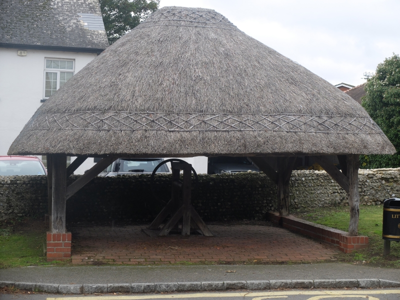
5/9 Wellhead
27.9.85 II
Well head. C17, with C20 restoration. Almost square open structure, timber-
framed with braces to the angle posts. Hipped thatch roof. C20 brick floor and
kerbs. In the centre there is the timber-framed winding gear and boarded well
cover.
External links are from the relevant listing authority and, where applicable, Wikidata. Wikidata IDs may be related buildings as well as this specific building. If you want to add or update a link, you will need to do so by editing the Wikidata entry.


Other nearby listed buildings
