Approximate Location Map
Large Map »
Latitude: 50.9954 / 50°59'43"N
Longitude: -1.0313 / 1°1'52"W
OS Eastings: 468074
OS Northings: 122228
OS Grid: SU680222
Mapcode National: GBR B9V.J2X
Mapcode Global: FRA 86QH.40C
Plus Code: 9C2WXXW9+5F
Entry Name: Barn 40 Metres West of Courthouse
Listing Date: 16 March 1954
Grade: II
Source: Historic England
Source ID: 1351117
English Heritage Legacy ID: 142851
ID on this website: 101351117
Location: East Meon, East Hampshire, GU32
County: Hampshire
District: East Hampshire
Civil Parish: East Meon
Built-Up Area: East Meon
Traditional County: Hampshire
Lieutenancy Area (Ceremonial County): Hampshire
Church of England Parish: East Meon All Saints
Church of England Diocese: Portsmouth
Tagged with: Barn
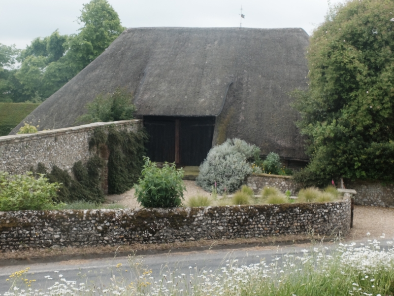
6822 EAST MEON CHURCH ROAD
12/9 Barn 40 metres west of
16.3.54 courthouse
GV II
Barn, used as garage and store. C17. Timber frame with Queen post truss, and
some arch bracing. Walls of flint with brick dressings. Rectangle of three
bays, with aisles all round, and central wagon entrance.
External links are from the relevant listing authority and, where applicable, Wikidata. Wikidata IDs may be related buildings as well as this specific building. If you want to add or update a link, you will need to do so by editing the Wikidata entry.


Other nearby listed buildings
