Approximate Location Map
Large Map »
Latitude: 51.0222 / 51°1'20"N
Longitude: -0.9379 / 0°56'16"W
OS Eastings: 474588
OS Northings: 125298
OS Grid: SU745252
Mapcode National: GBR CBX.X9D
Mapcode Global: FRA 86XD.Y66
Plus Code: 9C3X23C6+VR
Entry Name: Church of All Saints
Listing Date: 16 March 1954
Grade: II*
Source: Historic England
Source ID: 1351171
English Heritage Legacy ID: 143244
ID on this website: 101351171
Location: All Saints' Church, Steep, East Hampshire, GU32
County: Hampshire
District: East Hampshire
Civil Parish: Steep
Built-Up Area: Steep
Traditional County: Hampshire
Lieutenancy Area (Ceremonial County): Hampshire
Church of England Parish: Steep All Saints
Church of England Diocese: Portsmouth
Tagged with: Church building
STEEP CHURCH ROAD
SU 72 NW
9/49 CHURCH OF ALL SAINTS
16.3.54
GV II*
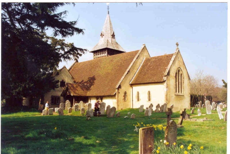
Parish church. C12, C13, C14, 1838 and 1875. Rubble walls of different dates,
some cemented sections, stone dressings, buttresses at the west end. Tile roof.
Nave and chancel, with south aisle (four bays) of 1180, north chapel and west tower
added but later (c.1200) merged as a wide north aisle, chancel renewed C13, upper
part of tower 1875 by R W Edis, c19 north and south porches. The exterior has
lancets, some of the C13, with a cinquefoil above the west end of the nave. The
prominent bell tower has a steeple with exaggerated broaches, a timber-framed bell
stage, and battered sides hung with scalloped tiles. Inside, the arcades are
supported by cylindrical columns, the earlier on the south side with scalloped
caps, the north having moulded caps: there are remains of the rood stair. A late
medieval roof has king posts (the nave with modern tie-beams). The C14 font is
hexagonal on six short shafts around a central shaft. There are wall monuments of
1740, 1741, 1743, 1756, 1780, 1820, 1829 and others of the early c19. A window
contains etched glass, as a memorial to the poet Edward Thomas.
Listing NGR: SU7464025294
External links are from the relevant listing authority and, where applicable, Wikidata. Wikidata IDs may be related buildings as well as this specific building. If you want to add or update a link, you will need to do so by editing the Wikidata entry.


Other nearby listed buildings
