Approximate Location Map
Large Map »
Latitude: 51.0595 / 51°3'34"N
Longitude: -1.3152 / 1°18'54"W
OS Eastings: 448089
OS Northings: 129124
OS Grid: SU480291
Mapcode National: GBR 861.J9F
Mapcode Global: FRA 864B.1GH
Plus Code: 9C3W3M5M+QW
Entry Name: 5, St Swithun Street
Listing Date: 14 January 1974
Grade: II
Source: Historic England
Source ID: 1095356
English Heritage Legacy ID: 144807
ID on this website: 101095356
Location: The Close, Winchester, Hampshire, SO23
County: Hampshire
District: Winchester
Electoral Ward/Division: St Michael
Parish: Non Civil Parish
Built-Up Area: Winchester
Traditional County: Hampshire
Lieutenancy Area (Ceremonial County): Hampshire
Church of England Parish: Winchester St Lawrence with St Swithun-upon-Kingsgate
Church of England Diocese: Winchester
Tagged with: Building
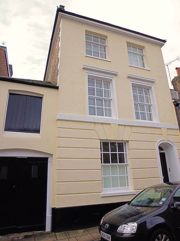
ST SWITNUN STREET
1.
1833
No 5
SU 4829 SW 6/417
II
2.
Circa 1840. Rendered, grooved on the ground floor. Three storeys, two
windows, sashes with glazing bars. Arched doorway with keystone. Hipped
slate roof.
Listing NGR: SU4808829122
External links are from the relevant listing authority and, where applicable, Wikidata. Wikidata IDs may be related buildings as well as this specific building. If you want to add or update a link, you will need to do so by editing the Wikidata entry.


Other nearby listed buildings
