Approximate Location Map
Large Map »
Latitude: 52.0944 / 52°5'39"N
Longitude: -1.9471 / 1°56'49"W
OS Eastings: 403719
OS Northings: 244012
OS Grid: SP037440
Mapcode National: GBR 3LB.LJW
Mapcode Global: VHB0T.6MH8
Plus Code: 9C4W33V3+Q5
Entry Name: 67 and 69, High Street
Listing Date: 24 June 1977
Grade: II
Source: Historic England
Source ID: 1302908
English Heritage Legacy ID: 147441
ID on this website: 101302908
Location: Evesham, Wychavon, Worcestershire, WR11
County: Worcestershire
District: Wychavon
Civil Parish: Evesham
Built-Up Area: Evesham
Traditional County: Worcestershire
Lieutenancy Area (Ceremonial County): Worcestershire
Church of England Parish: Evesham All Saints with St Lawrence
Church of England Diocese: Worcester
Tagged with: Building
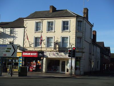
HIGH STREET
1.
5249
(West Side)
Nos 67 and 69
SP 0344 SE 2/44
II GV
2.
Late C18. Stucco; 3 storeys; quoins at sides; 3 sash windows (single glazing bars
only) in moulded architraves; slates. Modern shop fronts.
Nos 45 to 51 (odd). Railings and lamp standards of No 51 and Nos 55 to 69 (odd)
form a group.
Listing NGR: SP0371444009
External links are from the relevant listing authority and, where applicable, Wikidata. Wikidata IDs may be related buildings as well as this specific building. If you want to add or update a link, you will need to do so by editing the Wikidata entry.


Other nearby listed buildings
