Approximate Location Map
Large Map »
Latitude: 52.0934 / 52°5'36"N
Longitude: -1.9464 / 1°56'47"W
OS Eastings: 403765
OS Northings: 243894
OS Grid: SP037438
Mapcode National: GBR 3LB.LQR
Mapcode Global: VHB0T.6NV2
Plus Code: 9C4W33V3+9C
Entry Name: 38, High Street
Listing Date: 24 June 1977
Grade: II
Source: Historic England
Source ID: 1081383
English Heritage Legacy ID: 147450
ID on this website: 101081383
Location: Evesham, Wychavon, Worcestershire, WR11
County: Worcestershire
District: Wychavon
Civil Parish: Evesham
Built-Up Area: Evesham
Traditional County: Worcestershire
Lieutenancy Area (Ceremonial County): Worcestershire
Church of England Parish: Evesham All Saints with St Lawrence
Church of England Diocese: Worcester
Tagged with: Building
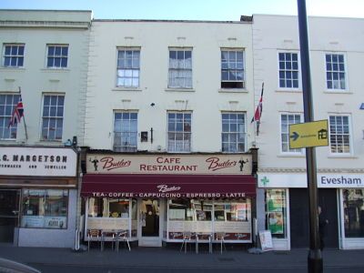
HIGH STREET
1.
5249
(East Side)
No 38
SP 0343 NE 1/52
II GV
2.
Late C18. Painted and engraved stucco; 3 storeys; 3 sash windows with moulded
keyblocks and channelled lintels; long and short quoins on left-hand side only;
parapet. Late C19 restaurant front.
Nos 30 to 46 (even) and No 5O form a group.
Listing NGR: SP0377243892
External links are from the relevant listing authority and, where applicable, Wikidata. Wikidata IDs may be related buildings as well as this specific building. If you want to add or update a link, you will need to do so by editing the Wikidata entry.


Other nearby listed buildings
