Approximate Location Map
Large Map »
Latitude: 52.2031 / 52°12'11"N
Longitude: -2.1139 / 2°6'49"W
OS Eastings: 392314
OS Northings: 256103
OS Grid: SO923561
Mapcode National: GBR 2HF.SGL
Mapcode Global: VH92P.9WVG
Plus Code: 9C4V6V3P+6F
Entry Name: The Old Granary
Listing Date: 4 September 1986
Grade: II
Source: Historic England
Source ID: 1179136
English Heritage Legacy ID: 147713
ID on this website: 101179136
Location: Crowle, Wychavon, Worcestershire, WR7
County: Worcestershire
District: Wychavon
Civil Parish: Crowle
Built-Up Area: Crowle
Traditional County: Worcestershire
Lieutenancy Area (Ceremonial County): Worcestershire
Church of England Parish: Crowle with Bredicot
Church of England Diocese: Worcester
Tagged with: Granary
This list entry was subject to a Minor Amendment on 17 February 2023 to update the name and address and to reformat the text to current standards
SO 95 NW
6/36
CROWLE CP
SCHOOL LANE (south side)
The Old Granary
(Formerly listed as Granary about 30 yards east of New House Farmhouse)
II
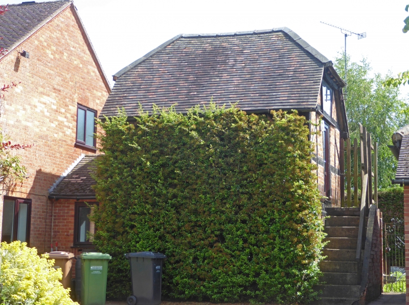
Granary, now store. C17, with mid-C20 alterations. Timber framed, rendered and brick infill, half-hipped plain tiled roof. One framed bay on east/west axis; two levels.
Framing: upper level has two rows of square panelling with short straight braces in upper corners and truncated collar and tie-beam trusses at gable ends with two raking struts below collar; brick walling between corner posts at ground-floor level. North front elevation: open at ground-floor level with partition dividing space laterally situated to left of centre. At west gable end brick and concrete steps lead up to ledged and battened door into upper level, above which is a lean-to canopy on brackets; above the canopy is a wood latticed ventilation panel between the raking struts.
Listing NGR: SO9231456103
External links are from the relevant listing authority and, where applicable, Wikidata. Wikidata IDs may be related buildings as well as this specific building. If you want to add or update a link, you will need to do so by editing the Wikidata entry.


Other nearby listed buildings
