Approximate Location Map
Large Map »
Latitude: 52.2559 / 52°15'21"N
Longitude: -2.1237 / 2°7'25"W
OS Eastings: 391650
OS Northings: 261981
OS Grid: SO916619
Mapcode National: GBR 1FH.HX8
Mapcode Global: VH92H.4KMG
Plus Code: 9C4V7V4G+9G
Entry Name: Three Wells
Listing Date: 4 September 1986
Grade: II
Source: Historic England
Source ID: 1081244
English Heritage Legacy ID: 147722
ID on this website: 101081244
Location: Hadzor, Wychavon, Worcestershire, WR9
County: Worcestershire
District: Wychavon
Civil Parish: Hadzor
Traditional County: Worcestershire
Lieutenancy Area (Ceremonial County): Worcestershire
Church of England Parish: Hadzor with Oddingley and Tibberton
Church of England Diocese: Worcester
Tagged with: Building
HADZOR CP HADZOR LANE (east side)
SO 96 SW
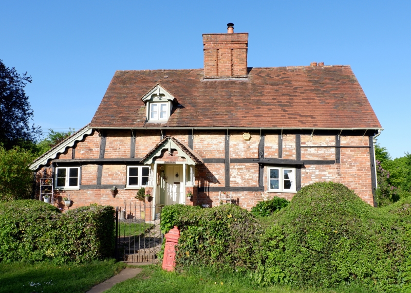
3/46 Three Wells
GV II
House. Late C16 with mid- to late C19 and early C20 alterations and
additions. Timber-framed, brick infill, tall plinth, replacement walling
and additions, plain tiled roof. L-plan; main range aligned north-west/
south-east of three framed bays, central bay mainly occupied by chimney
which has a group of three square stacks with chamfered corners; also timber-
framed outshut at north-west gable end; two framed bay rear range to south-
east bay with chimney at junction of two ranges. Main range is single storey
and attic with dormers; rear range is two storeys. Framing: main range has
two large square panels from sill to wall-plate and collar and tie-beam
trusses with two vertical struts to collar; rear range has two rows of small
rectangular panels at first-floor level, lower floor screened behind later
extensions apart from south-east elevation which has brick replacement walling;
north-west gable end has collar and tie-beam truss with broad raking struts.
North-west front elevation: ground floor has a window in each of the outer
bays, both with plank weatherings, the left side one continuing across the
window in the outshut; two gabled dormers; all windows are 2-light casements;
main entrance in left bay has gabled porch, balustraded on brick base and
ledged and battened door; dormers, porch and gable ends all have scalloped
bargeboards. Attic lights in gable ends. South-east elevation of rear range
has similar porch to that on front elevation. Interior: main range has large
back-to-back fireplaces; stop-chamfered main beams. C19 outshut at rear gable
end and C20 single storey extension in angle between two ranges. The house
was once divided into three dwellings, each having its own well.
Listing NGR: SO9165061981
External links are from the relevant listing authority and, where applicable, Wikidata. Wikidata IDs may be related buildings as well as this specific building. If you want to add or update a link, you will need to do so by editing the Wikidata entry.


Other nearby listed buildings
