Approximate Location Map
Large Map »
Latitude: 52.2165 / 52°12'59"N
Longitude: -2.0838 / 2°5'1"W
OS Eastings: 394373
OS Northings: 257595
OS Grid: SO943575
Mapcode National: GBR 2HG.201
Mapcode Global: VH92P.TKR4
Plus Code: 9C4V6W88+JF
Entry Name: Hall Farmhouse
Listing Date: 4 September 1986
Grade: II
Source: Historic England
Source ID: 1301740
English Heritage Legacy ID: 147855
ID on this website: 101301740
Location: Huddington, Wychavon, Worcestershire, WR9
County: Worcestershire
District: Wychavon
Civil Parish: Huddington
Traditional County: Worcestershire
Lieutenancy Area (Ceremonial County): Worcestershire
Church of England Parish: Huddington
Church of England Diocese: Worcester
Tagged with: Farmhouse
HUDDINGTON CP HUDDINGTON
SO 95 NW
6/179 Hall Farmhouse
- II
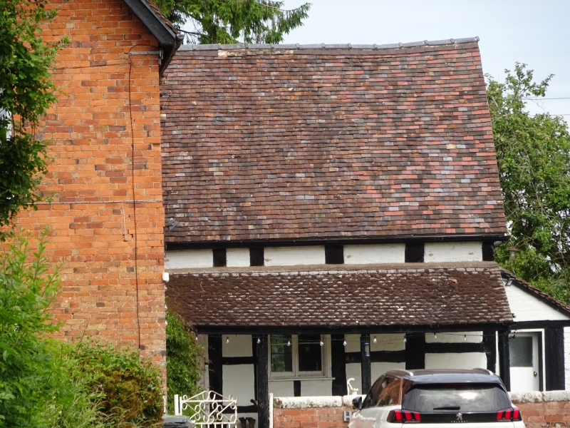
Farmhouse. c1600 or earlier origins, partly rebuilt early C18; remodelled
late C19. Part timber-framed with painted brick infill on brick plinth,
part brick including some handmade bricks, plain tiled roofs. Timber-framed
part of two framed bays aligned east/west. Single storey and attic.
Framing: three rows of panels from sill to wall-plate, collar and tie-beam
truss in east gable end with two struts to collar, raking struts across lower
corners and V-strut in apex. Main south elevation: tiled verandah on moulded
timber posts runs full length; ground floor has a 2-light casement and a half-
glazed door. C19 lean-to addition at east gable end and attic light above.
The rebuilt part adjoins the west gable end; F-plan with the main part aligned
north/south and two west wings. Two storeys, 3-course band with central blue
brick cogged course between storeys. Main east elevation: four bays; three
ground- and first-floor 3-light casements with cambered heads; the timber-
framed part projects from the fourth bay; two ridge stacks, one stack to rear
of ridge and one at junction with south-west wing. Interior not inspected.
Listing NGR: SO9437357595
External links are from the relevant listing authority and, where applicable, Wikidata. Wikidata IDs may be related buildings as well as this specific building. If you want to add or update a link, you will need to do so by editing the Wikidata entry.


Other nearby listed buildings
