Approximate Location Map
Large Map »
Latitude: 52.2126 / 52°12'45"N
Longitude: -2.1444 / 2°8'39"W
OS Eastings: 390231
OS Northings: 257163
OS Grid: SO902571
Mapcode National: GBR 1G1.BN2
Mapcode Global: VH92N.SN65
Plus Code: 9C4V6V74+26
Entry Name: Lawn Farmhouse
Listing Date: 4 September 1986
Grade: II
Source: Historic England
Source ID: 1350177
English Heritage Legacy ID: 147883
ID on this website: 101350177
Location: Tibberton, Wychavon, Worcestershire, WR9
County: Worcestershire
District: Wychavon
Civil Parish: Tibberton
Built-Up Area: Tibberton
Traditional County: Worcestershire
Lieutenancy Area (Ceremonial County): Worcestershire
Church of England Parish: Hadzor with Oddingley and Tibberton
Church of England Diocese: Worcester
Tagged with: Farmhouse
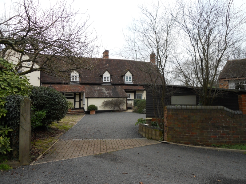
TIBBERTON CP off CHURCH LANE (west side)
SO 95 NW
6/207 Lawn Farmhouse
- II
Farmhouse, now house. Late C16, remodelled c1856 with mid-C20 alterations
and additions. Part timber-framed with painted brick and rendered infill,
part painted brick, plain tiled roofs. Four framed bays aligned roughly
north/south with large external chimney at north gable end now enclosed by
C20 cross-wing. Partly single storey and attic with dormers, partly two
storeys with dentilled eaves cornice. Framing: mainly three panels from
sill to wall-plate with some large swept braces in lower corners; trusses
not visible. West front elevation: ground floor has a 2-light casement,
two narrow lights and three gabled dormers with 2-light casements; C20 door
in the northernmost bay flanked by C20 rectangular lights and a half-glazed
door in the southernmost bay; there is a central lean-to addition. Interior
not inspected but noted as having retained much of its internal framing
including its moulded main ceiling beams. The roof has been raised to the
rear elevation. There is a gabled mid-C19 porch at rear with pointed lights
and doorhead. At the south gable end a semi-circular lias limestone rubble
bread oven has been retained. C20 cross-wing is not included.
Listing NGR: SO9023157163
External links are from the relevant listing authority and, where applicable, Wikidata. Wikidata IDs may be related buildings as well as this specific building. If you want to add or update a link, you will need to do so by editing the Wikidata entry.


Other nearby listed buildings
