Approximate Location Map
Large Map »
Latitude: 52.2286 / 52°13'43"N
Longitude: -2.165 / 2°9'53"W
OS Eastings: 388829
OS Northings: 258950
OS Grid: SO888589
Mapcode National: GBR 1FT.CFG
Mapcode Global: VH92N.F7BV
Plus Code: 9C4V6RHP+F2
Entry Name: Granary South-West of Lower Smite Farmhouse
Listing Date: 21 March 1985
Grade: II
Source: Historic England
Source ID: 1350182
English Heritage Legacy ID: 147907
ID on this website: 101350182
Location: Wychavon, Worcestershire, WR3
County: Worcestershire
District: Wychavon
Civil Parish: Hindlip
Traditional County: Worcestershire
Lieutenancy Area (Ceremonial County): Worcestershire
Church of England Parish: Salwarpe and Hindlip with Martin Hussingtree
Church of England Diocese: Worcester
Tagged with: Granary
SO 85 NE HINDLIP CP SMITE
7/12 Granary south-west of
Lower Smite Farmhouse
-
GV II
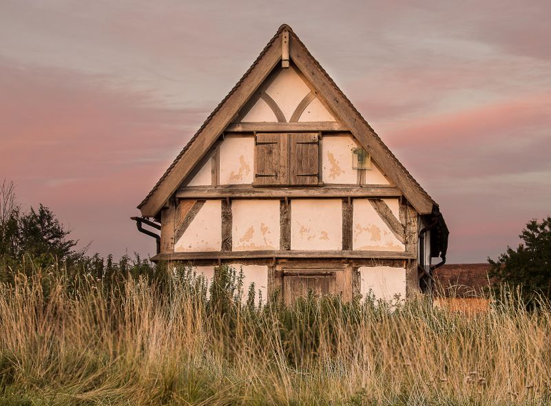
Granary. Late C17/early C18. Timber-framed, brick infill, part weatherboarded,
on high brick, sandstone and blue lias limestone rubble plinth, plain tiled roof.
Two framed bays; single storey and attic, on steep slope enabling base to be
used, probably for cart storage. Framing : 3 square panels from sill to wall-
plate, short straight braces in upper corners, collar and tie-beam trusses
with queen struts in gable ends. Ledged and battened door in south side
elevation; east gable end has wide doorway in plinth, rectangular ground floor
opening and wood panel in apex with 2 alighting ledges and 5 access holes for
pigeons; there is a 2-light wood mullioned window in the ground floor of the
west gable end. Interior: roof of trenched, single purlins and intermediate
tie-beam truss with queen struts. Ground floor and attic plastered throughout;
attic has plastered ceiling at collar level. Previously listed as a dovecote.
Listing NGR: SO8882958950
External links are from the relevant listing authority and, where applicable, Wikidata. Wikidata IDs may be related buildings as well as this specific building. If you want to add or update a link, you will need to do so by editing the Wikidata entry.


Other nearby listed buildings
