Approximate Location Map
Large Map »
Latitude: 52.092 / 52°5'31"N
Longitude: -1.8642 / 1°51'50"W
OS Eastings: 409403
OS Northings: 243749
OS Grid: SP094437
Mapcode National: GBR 3LF.X2S
Mapcode Global: VHB0V.MPV4
Plus Code: 9C4W34RP+R8
Entry Name: Upper End Farmhouse
Listing Date: 30 July 1959
Grade: II
Source: Historic England
Source ID: 1301413
English Heritage Legacy ID: 148661
ID on this website: 101301413
Location: Bretforton, Wychavon, Worcestershire, WR11
County: Worcestershire
District: Wychavon
Civil Parish: Bretforton
Built-Up Area: Bretforton
Traditional County: Worcestershire
Lieutenancy Area (Ceremonial County): Worcestershire
Church of England Parish: Bretforton
Church of England Diocese: Worcester
Tagged with: Farmhouse
BRETFORTON CP MAIN STREET (south side)
SP 0843 - SP 0943
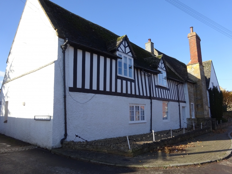
15/58 Upper End Farmhouse
(No 73)
30.7.59
GV II
Farmhouse. Probably C16, extended late C17 and restored mid-C20. Timber-
frame with rendered infill on roughcast ground floor extended in lias rubble
with ashlar quoins partially rendered, all with Cotswold stone and tile roof.
L-plan, limb to south-east of three bays is C16, to south-west C17. South-east
gable-end stack and lateral stack to front (north-east) wall. North-east front:
to left of one storey with attic lit by two gabled dormers, with a 3-light case-
ment below to left and 6-pane boxed sash to right. Entrance at right-hand corner
has a half-glazed door. Gable of cross-wing to left of one storey with gable-
lit attic and a 3-light stone mullioned window below with square label.
Framing: restored to front, but to rear close-studded with curved tension
brace to first floor. Interior: massive ceiling beams to ground floor. Moulded
stone fireplace to the lateral stack.
Listing NGR: SP0939343743
External links are from the relevant listing authority and, where applicable, Wikidata. Wikidata IDs may be related buildings as well as this specific building. If you want to add or update a link, you will need to do so by editing the Wikidata entry.


Other nearby listed buildings
