Approximate Location Map
Large Map »
Latitude: 52.267 / 52°16'1"N
Longitude: -2.7539 / 2°45'14"W
OS Eastings: 348646
OS Northings: 263469
OS Grid: SO486634
Mapcode National: GBR BJ.Z8PH
Mapcode Global: VH84P.68ZZ
Plus Code: 9C4V768W+QC
Entry Name: Luston Court, Luston Court Cottage and Granary Cottage
Listing Date: 11 December 1987
Grade: II
Source: Historic England
Source ID: 1349886
English Heritage Legacy ID: 150088
ID on this website: 101349886
Location: Luston, County of Herefordshire, HR6
County: County of Herefordshire
Civil Parish: Luston
Built-Up Area: Luston
Traditional County: Herefordshire
Lieutenancy Area (Ceremonial County): Herefordshire
Church of England Parish: Eye
Church of England Diocese: Hereford
Tagged with: Cottage
This list entry was subject to a Minor Amendment on 11/03/2016
SO 4862
11/66
LUSTON CP,
EYE LANE (north side),
Luston Court, Luston Court Cottage and Granary Cottage
(Formerly listed as Luston Court and Luston Court Cottage)
GV II
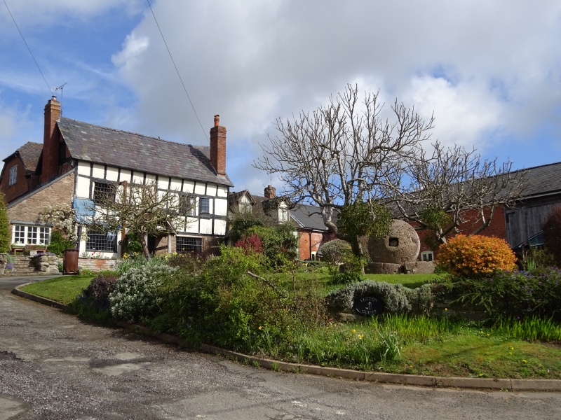
House, now three houses. Early C17, raised late C17, extended early C19.
Timber-frame with rendered infill on coursed rubble base with slate and
tile roofs. Three framed bays aligned east/west, with C19 parallel range
built behind, Luston Cottage in a lower framed bay to east of C17 block.
Gable-end external brick stack to west gable of C17 part, and to south-
east corner. South front of two storeys with gable-lit attic to main range,
three windows, two 2-light casements with a single-light casement to right.
Ground floor has two 3-light casements flanking the central entrance with
gabled and tiled porch and ledged and boarded door. Luston Cottage to
right is of one storey with attic lit by two gabled dormers. Ground floor
has a 4-light casement, to entrance to the left. Framing: one square panel
of a three-square panel frame survives, raised by a further two square panels.
Listing NGR: SO4864663469
External links are from the relevant listing authority and, where applicable, Wikidata. Wikidata IDs may be related buildings as well as this specific building. If you want to add or update a link, you will need to do so by editing the Wikidata entry.


Other nearby listed buildings
