Approximate Location Map
Large Map »
Latitude: 52.2636 / 52°15'48"N
Longitude: -2.7534 / 2°45'12"W
OS Eastings: 348678
OS Northings: 263093
OS Grid: SO486630
Mapcode National: GBR BJ.ZGTZ
Mapcode Global: VH84P.7C7K
Plus Code: 9C4V767W+CJ
Entry Name: Tudor House
Listing Date: 11 December 1987
Grade: II
Source: Historic England
Source ID: 1081802
English Heritage Legacy ID: 150094
ID on this website: 101081802
Location: Luston, County of Herefordshire, HR6
County: County of Herefordshire
Civil Parish: Luston
Built-Up Area: Luston
Traditional County: Herefordshire
Lieutenancy Area (Ceremonial County): Herefordshire
Church of England Parish: Eye
Church of England Diocese: Hereford
Tagged with: House
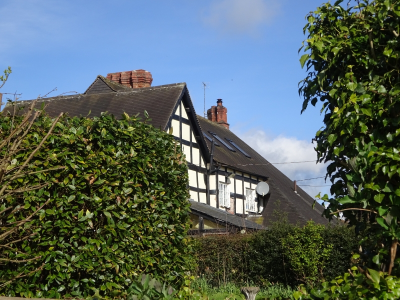
SO 4862 LUSTON CP MAIN STREET (east side)
11/72 Tudor House
GV II
House. Late C17, restored after fire 1940's. Timber-frame with rendered
infill and machine tile roof. T-plan, cross-wing aligned east/west, other
range to north. Main stack at junction with three linked brick shafts, six-
point star plan. West front of two storeys with gabled cross-wing to right.
Two plus one windows, that to left a 2-light oriel, then a 3-light casement
and a 3-light oriel. Ground floor had three plus one windows, a 2-light
casement to left, then two 3-light oriels and a 3-light casement. Entrance
to right-hand end of subsidiary range opens into a lobby against the stack.
It has a C20 doorcase with fluted pilasters and a C20 half-glazed door.
Framing: the whole front has a shallow jetty on scroll brackets, the bressummer
is moulded and dentilled. The framing of the subsidiary range is six square
panels high with a further narrow panel at the top. The cross-wing is also
six square panels high. The lower panels have semi-circular cuts in the studs
and rails of each panel, the upper have quadrant braces with nibs. The gable
above has a projecting dentilled tie-beam and dentilled bargeboards. (RCHM, 3,
p 138, no 1).
Listing NGR: SO4867863093
External links are from the relevant listing authority and, where applicable, Wikidata. Wikidata IDs may be related buildings as well as this specific building. If you want to add or update a link, you will need to do so by editing the Wikidata entry.


Other nearby listed buildings
