Approximate Location Map
Large Map »
Latitude: 52.3125 / 52°18'45"N
Longitude: -2.5956 / 2°35'44"W
OS Eastings: 359494
OS Northings: 268433
OS Grid: SO594684
Mapcode National: GBR BQ.WKP3
Mapcode Global: VH84K.Y4PK
Plus Code: 9C4V8C73+2Q
Entry Name: Cider House, Coopers House and Millers House
Listing Date: 24 October 1988
Grade: II
Source: Historic England
Source ID: 1349578
English Heritage Legacy ID: 150772
ID on this website: 101349578
Location: Tenbury Wells, Malvern Hills, Worcestershire, WR15
County: Worcestershire
District: Malvern Hills
Civil Parish: Tenbury
Built-Up Area: Tenbury Wells
Traditional County: Worcestershire
Lieutenancy Area (Ceremonial County): Worcestershire
Church of England Parish: Tenbury Wells
Church of England Diocese: Hereford
Tagged with: Architectural structure
This list entry was subject to a Minor Amendment on 18/05/2015
SO 5868 - 5968
8/81
TENBURY CP
CHURCH STREET (east side)
Cider house, Coopers House and Millers House
(Formerly listed as Warehouse and hop kiln about 10 yards east of Church House)
GV
II
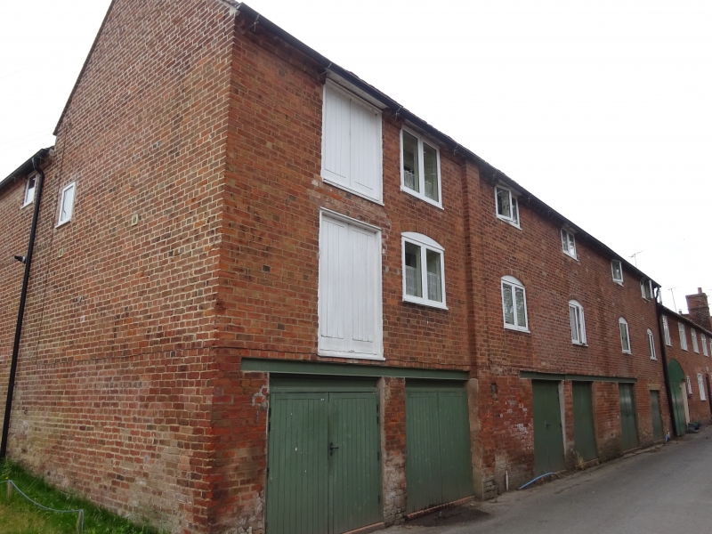
Former warehouse and hop kiln. Mid- to late C18, altered mid-C19 and mid-C20.
Brick with plain tiled roofs. Three levels with dentilled eaves cornice. Six bays with brick pilaster buttress between bays 2 and 3. There are 2-light windows in bays 2 to 5 on both upper floors; the first floor level windows have cambered heads. Bay 1 has a loft door on both upper floor levels. The ground floor has a C20 horizontally sliding door in each bay. Hop kiln situated to rear left. Square plan with pyramidal roof surmounted by a tall boarded timber lantern with a shallow pyramidal roof and finial. The north elevation has a central doorway with partly-glazed recessed double doors and a small square light at eaves level. Interior: the interior of the kiln has a two-course band about half-way up the lower storey. The drying floor survives.
Listing NGR: SO5949468433
External links are from the relevant listing authority and, where applicable, Wikidata. Wikidata IDs may be related buildings as well as this specific building. If you want to add or update a link, you will need to do so by editing the Wikidata entry.


Other nearby listed buildings
