Approximate Location Map
Large Map »
Latitude: 52.3091 / 52°18'32"N
Longitude: -2.5961 / 2°35'46"W
OS Eastings: 359454
OS Northings: 268052
OS Grid: SO594680
Mapcode National: GBR BQ.WRKY
Mapcode Global: VH84K.Y7D6
Plus Code: 9C4V8C53+JH
Entry Name: The Kings Head Inn
Listing Date: 6 October 1952
Grade: II
Source: Historic England
Source ID: 1082431
English Heritage Legacy ID: 150784
ID on this website: 101082431
Location: Tenbury Wells, Malvern Hills, Worcestershire, WR15
County: Worcestershire
District: Malvern Hills
Civil Parish: Tenbury
Built-Up Area: Tenbury Wells
Traditional County: Worcestershire
Lieutenancy Area (Ceremonial County): Worcestershire
Church of England Parish: Tenbury Wells
Church of England Diocese: Hereford
Tagged with: Inn
TENBURY CP CROSS STREET (west side)
SO 5868 - 5968
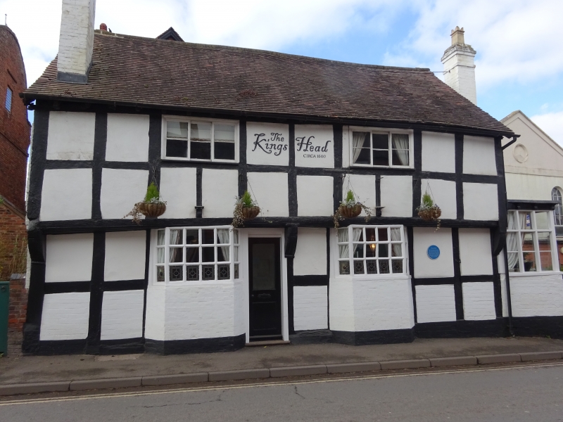
8/93 The King's Head Inn
6.10.52
GV II
Public house. Late C16 with circa 1800 and late C19 alterations. Timber-
framed with painted brick and rendered infill, brick replacement walling
and additions, plain tiled roofs and brick stack to south of front roof
pitch. Two framed bays aligned north/south; external chimney with tall
detached rebuilt brick stack at north end. Two storeys. Framing: four
rows of panels from sill to wall-plate. East front elevation has a jettied
first floor with a moulded bressummer on shaped brackets enriched with weather-
worn foliated carving. Collar and tie-beam truss with three struts below
collar and V-strut above at north end. East front elevation: ground floor
has two bays windows, first floor has two 3-light windows. Central entrance
with half-glazed door. Main entrance at north end and has a flat moulded
canopy, panelled surround and a door with four flush panels. External north
chimney is enclosed by a flat roofed single-storey addition with multi-paned
windows to the north and east. Circa 1800 parallel range at rear and sub-
stantial late C19 brick addition to south-west. (VCH IV, p 363; BoE, p 279).
Listing NGR: SO5945468052
External links are from the relevant listing authority and, where applicable, Wikidata. Wikidata IDs may be related buildings as well as this specific building. If you want to add or update a link, you will need to do so by editing the Wikidata entry.


Other nearby listed buildings
