Approximate Location Map
Large Map »
Latitude: 52.1857 / 52°11'8"N
Longitude: -2.3149 / 2°18'53"W
OS Eastings: 378566
OS Northings: 254206
OS Grid: SO785542
Mapcode National: GBR 0DP.X4T
Mapcode Global: VH92R.TBK9
Plus Code: 9C4V5MPP+72
Entry Name: Lower Court Farmhouse
Listing Date: 15 October 1984
Grade: II
Source: Historic England
Source ID: 1082942
English Heritage Legacy ID: 151699
ID on this website: 101082942
Location: Cotheridge, Malvern Hills, Worcestershire, WR6
County: Worcestershire
District: Malvern Hills
Civil Parish: Cotheridge
Traditional County: Worcestershire
Lieutenancy Area (Ceremonial County): Worcestershire
Church of England Parish: The Lower Teme Valley Parish
Church of England Diocese: Worcester
Tagged with: Farmhouse
SO 75 SE COTHERIDGE CP CHURCH LANE
(west side)
5/29 Lower Court Farmhouse
29 7 59
GV II
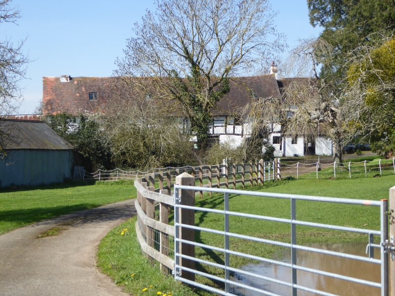
Farmhouse. Late C16, C19 alterations and additions. Timber-framed, part
plastered, part painted brick replacement walling and refacing, tiled and
slate roofs, large brick ridge stack with tiled offsets. Main range of
3 framed bays, two 2-bay cross-wings and additional bay extending south
with a separate roofed single bay dairy wing to front. Two storeys and
attic. Framing not visible. Front elevation C19 lean-to extension runs
across main range and left cross-wing, with slate roof and encorporating
2 sashes with small side panes and a half-glazed door to right flanked by
a large and a small casement; right cross-wing has a C20 casement; 2 first
floor casements in main range; first floor casement and attic lights in
cross-wing gable ends. A half-glazed lean-to porch is situated in the
angle between the lean-to extension and dairy wing, with a first floor case-
ment above. Front of dairy wing has a lean-to extension with 2 casements
and a planked door and wood-mullioned first floor window. Interior Much
altered. Roof has raking strut trusses and single, trenched purlins,
sections of which have been removed. Main beams are stop-chamfered. There
is a C19 outshut to the north side elevation and a C19 two storey extension
to the rear right.
Listing NGR: SO7856654206
External links are from the relevant listing authority and, where applicable, Wikidata. Wikidata IDs may be related buildings as well as this specific building. If you want to add or update a link, you will need to do so by editing the Wikidata entry.


Other nearby listed buildings
