Approximate Location Map
Large Map »
Latitude: 52.0372 / 52°2'14"N
Longitude: -2.4223 / 2°25'20"W
OS Eastings: 371126
OS Northings: 237731
OS Grid: SO711377
Mapcode National: GBR FZ.FV1J
Mapcode Global: VH860.Y2S2
Plus Code: 9C4V2HPH+V3
Entry Name: The Town Council Offices
Listing Date: 18 September 1953
Last Amended: 5 November 1976
Grade: II*
Source: Historic England
Source ID: 1082903
English Heritage Legacy ID: 151818
ID on this website: 101082903
Location: Ledbury, County of Herefordshire, HR8
County: County of Herefordshire
Civil Parish: Ledbury
Built-Up Area: Ledbury
Traditional County: Herefordshire
Lieutenancy Area (Ceremonial County): Herefordshire
Church of England Parish: Ledbury
Church of England Diocese: Hereford
Tagged with: City hall Seat of local government
SO 7137 NE 2/8
18.9.53.
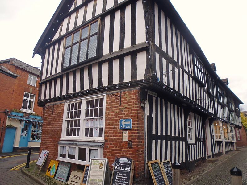
CHURCH LANE(North Side)
The Town Council Offices and No 3 (formerly listed as Ledbury Urban District Council Offices)
GII*
The earliest part on the south is C15 and extended eastwards circa 1600.A double gabled wing to the north (rear) was added also circa1600.C18 alterations.Exposed timber framing.Two storeys and dormers.On the earliest part facing Church Lane the timber framing is close set and the first floor projects along the whole south front on a moulded bressumer and corbels.Three and five-light casement windows in projecting frames with old wooden mullions and transoms.The ground floor has three small early C19 canted bays with glazing bars.The west end has a high brick base.The north(rear) is timber framed and the wide panels are plastered.Interior south:dragon ceiling beam,late C16 or early C17 panelling with cornice and fluted frieze,under the ceiling beam are pilasters with panels of carved foliage. RCHM (65).The Town Council offices, No 3, Public Lavatories, Hawkes and Terry Prince of Wales Inn, The Old Grammar School and Rutherglen form a group.
Listing NGR: SO7112637731
External links are from the relevant listing authority and, where applicable, Wikidata. Wikidata IDs may be related buildings as well as this specific building. If you want to add or update a link, you will need to do so by editing the Wikidata entry.


Other nearby listed buildings
