Approximate Location Map
Large Map »
Latitude: 52.0335 / 52°2'0"N
Longitude: -2.4221 / 2°25'19"W
OS Eastings: 371140
OS Northings: 237321
OS Grid: SO711373
Mapcode National: GBR FZ.G1SD
Mapcode Global: VH860.Y4XX
Plus Code: 9C4V2HMH+C5
Entry Name: 39 and 40, the Southend
Listing Date: 5 November 1976
Grade: II
Source: Historic England
Source ID: 1349400
English Heritage Legacy ID: 151988
ID on this website: 101349400
Location: Ledbury, County of Herefordshire, HR8
County: County of Herefordshire
Civil Parish: Ledbury
Built-Up Area: Ledbury
Traditional County: Herefordshire
Lieutenancy Area (Ceremonial County): Herefordshire
Church of England Parish: Ledbury
Church of England Diocese: Hereford
Tagged with: Building
1.
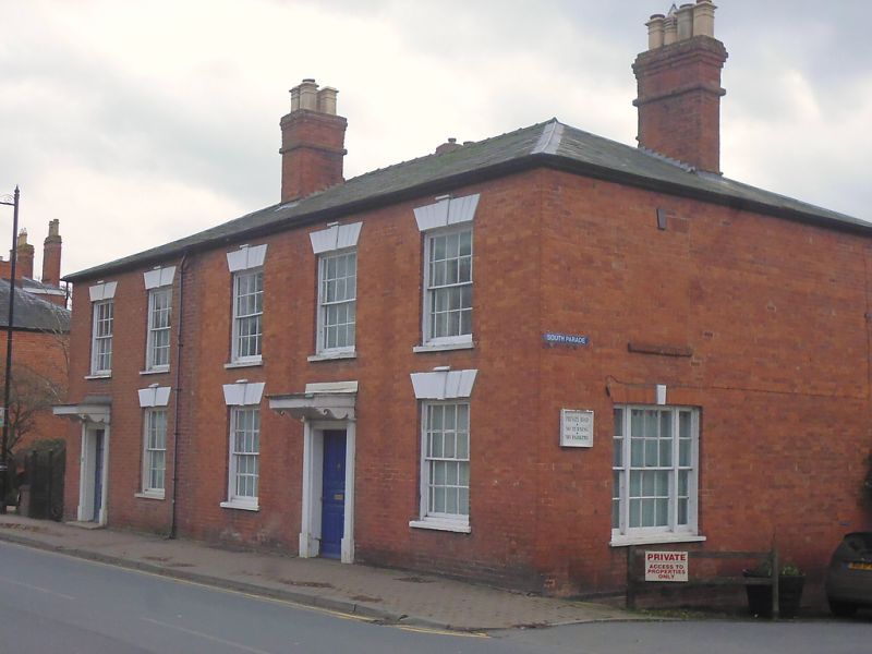
5245 THE SOUTHEND
(West Side)
------------
Nos 39 and 40
SO 7137 SE 2/210
II GV
2.
Early C19. Red brick. Slate hipped roof. 2 storeys. 5 windows. Sashes with
glazing bars and margin panes, and voussoired lintels with keyblock
Nos 39 to 45 (consec) form a group.
Listing NGR: SO7114037321
External links are from the relevant listing authority and, where applicable, Wikidata. Wikidata IDs may be related buildings as well as this specific building. If you want to add or update a link, you will need to do so by editing the Wikidata entry.


Other nearby listed buildings
