Approximate Location Map
Large Map »
Latitude: 52.106 / 52°6'21"N
Longitude: -2.2924 / 2°17'32"W
OS Eastings: 380068
OS Northings: 245335
OS Grid: SO800453
Mapcode National: GBR 0FP.WTD
Mapcode Global: VH935.6BYD
Plus Code: 9C4V4P45+92
Entry Name: 112, Guarlford Road
Listing Date: 11 May 1979
Grade: II
Source: Historic England
Source ID: 1082768
English Heritage Legacy ID: 152088
ID on this website: 101082768
Location: Hall Green, Malvern Hills, Worcestershire, WR14
County: Worcestershire
District: Malvern Hills
Civil Parish: Malvern
Built-Up Area: Great Malvern
Traditional County: Worcestershire
Lieutenancy Area (Ceremonial County): Worcestershire
Church of England Parish: Guarlford and Madresfield with Newland
Church of England Diocese: Worcester
Tagged with: Building
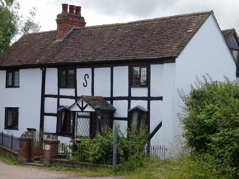
GUARLFORD ROAD
1.
5245
(South Side)
No 112
SO 84 NW 15/129
II GV
2.
C17 cottage with square panel timber-framing with brick infill. Tile roof,
brick stack. Two storeys, 3 windows, casements. Panelled door in gabled wood
porch.
Listing NGR: SO8006845335
External links are from the relevant listing authority and, where applicable, Wikidata. Wikidata IDs may be related buildings as well as this specific building. If you want to add or update a link, you will need to do so by editing the Wikidata entry.


Other nearby listed buildings
