Approximate Location Map
Large Map »
Latitude: 52.0843 / 52°5'3"N
Longitude: -2.1683 / 2°10'5"W
OS Eastings: 388562
OS Northings: 242898
OS Grid: SO885428
Mapcode National: GBR 1HK.BM6
Mapcode Global: VH937.CWK1
Plus Code: 9C4V3RMJ+PM
Entry Name: Dunstall Castle
Listing Date: 25 March 1968
Grade: II*
Source: Historic England
Source ID: 1082583
English Heritage Legacy ID: 152550
ID on this website: 101082583
Location: Malvern Hills, Worcestershire, WR8
County: Worcestershire
District: Malvern Hills
Civil Parish: Earl's Croome
Traditional County: Worcestershire
Lieutenancy Area (Ceremonial County): Worcestershire
Church of England Parish: Earl's Croome with Hill Croome and Strensham
Church of England Diocese: Worcester
Tagged with: Folly
SO 84 SE EARL'S CROOME DUNSTALL COMMON
3/45 Dunstall Castle
25.3.68
- II*
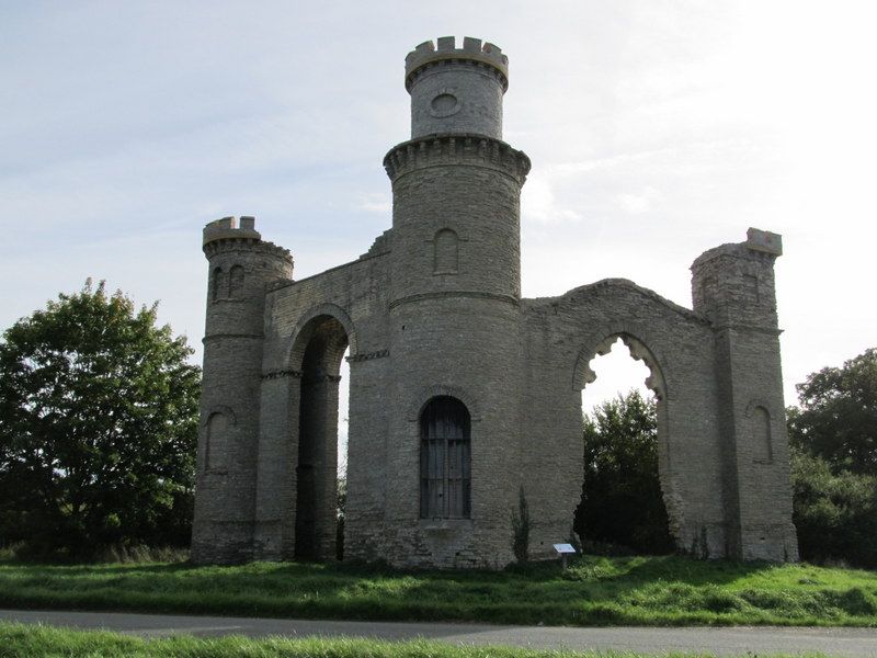
Folly ruin. c.1750-60, attributed to Sanderson Miller. Designed as an
eyecatcher ruined castle for the 6th Earl of Coventry, of Croome Court. Blue
lias random rubble. Central round tower with length of wall each side, canted
back and terminated in a smaller tower. Central tower with arched lower
opening, string course, blank arched panel above and ruined cap with machico-
lation. Plank door with studding to lower opening. Western side has wall with
shallow pitch gable springing from string course of tower and large ruined
Gothic window, the sill broken open to ground level, single rebate to jambs
and Bath stone cusping, like plate tracery to head. Wall terminated by a
narrow square tower with blank arched opening, string course, blank square
headed panel with keystone to top stage and another blank panel to East side
of top stage. No rear wall. Eastern side has double wall with large neo-
Norman round arch, dentilled string course at impost level and flat parapet,
terminated by round tower with single blank panel below and paired arched
panels to top stage, ruined machicolation. Within central tower a brick
staircase tower with stone winding steps.
Listing NGR: SO8856242898
External links are from the relevant listing authority and, where applicable, Wikidata. Wikidata IDs may be related buildings as well as this specific building. If you want to add or update a link, you will need to do so by editing the Wikidata entry.


Other nearby listed buildings
