Approximate Location Map
Large Map »
Latitude: 52.0075 / 52°0'27"N
Longitude: -2.5209 / 2°31'15"W
OS Eastings: 364338
OS Northings: 234470
OS Grid: SO643344
Mapcode National: GBR FV.HM9D
Mapcode Global: VH85Z.8S4X
Plus Code: 9C4V2F5H+2J
Entry Name: Chandos
Listing Date: 18 November 1952
Grade: II*
Source: Historic England
Source ID: 1099043
English Heritage Legacy ID: 152703
ID on this website: 101099043
Location: Rushall, County of Herefordshire, HR8
County: County of Herefordshire
Civil Parish: Much Marcle
Traditional County: Herefordshire
Lieutenancy Area (Ceremonial County): Herefordshire
Church of England Parish: Much Marcle with Yatton
Church of England Diocese: Hereford
Tagged with: Building
MUCH MARCLE CP -
SO 63 SW
7/38 Chandos
18.11.52
GV II*
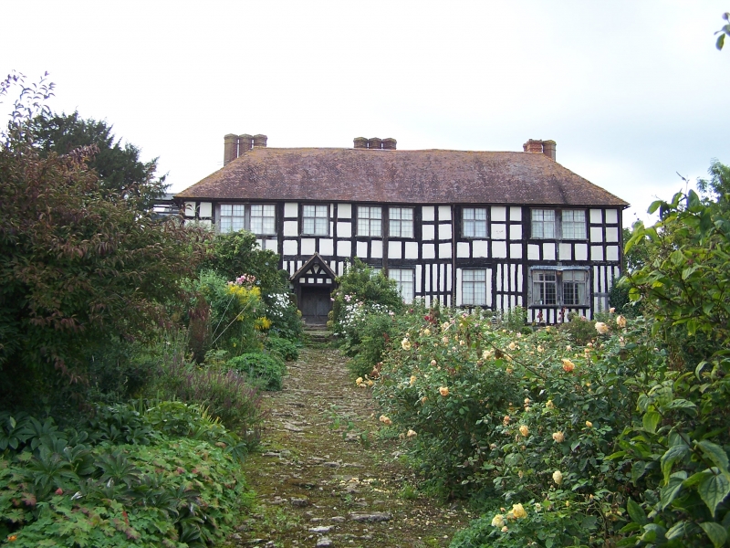
Farmhouse. Probably late C16 with C18 extensions. Timber-frame and
rubble partly rendered, stone slate roofs and brick stacks. Irregular
plan: C16 main range, with cross-passage and south porch, aligned east/
west, return wing on north side at west end and wide C18 projecting wing
added to south-west; two subsidiary ranges aligned north/south, probably
C18, for granary, pigeons and possibly cider, attached to north side of
main range by short parallel block. Two storeys. South elevation has
two windows, C18 casements to main range, three of three lights and one
four lights to principal ground-floor room to left hand side; centrally
placed gabled porch with heavy corner posts, now cased. C19 bargeboards,
ledged C17 door, ridge stack slightly to left of porch and rear off-ridge
stack to its right; projecting wing to left has two ground-floor casements,
the left hand one of three lights and the right of two lights, either side
of central rubble stack with brick shaft, some C18 narrow studs visible above
left window. East gable has herringbone struts from king-post. North side
of main range has heavy closely set studs to west of tallet stairs and
nesting ledges of rear parallel block. Interior: two segmentally-headed
entries from cross-passage to former kitchen at east end of principal
range; porch projects inwards over top of cross-passage with close studding;
principal room to west of cross-passage has deeply chamfered beams with
stops dividing ceiling into four main panels and smaller similar beams
further subdividing these, moulded jowl to wall-post in south-east corner.
A remarkably complete example of a higher ranking farmhouse. Serious roof
leaks to main range and dereliction of north parts at time of survey -
January 1985. (RCHM Vol II, p 132).
Listing NGR: SO6433834470
External links are from the relevant listing authority and, where applicable, Wikidata. Wikidata IDs may be related buildings as well as this specific building. If you want to add or update a link, you will need to do so by editing the Wikidata entry.


Other nearby listed buildings
