Approximate Location Map
Large Map »
Latitude: 52.0619 / 52°3'42"N
Longitude: -2.3402 / 2°20'24"W
OS Eastings: 376770
OS Northings: 240441
OS Grid: SO767404
Mapcode National: GBR 0G6.P51
Mapcode Global: VH93B.DF5Q
Plus Code: 9C4V3M65+PW
Entry Name: Milestone
Listing Date: 23 February 1987
Grade: II
Source: Historic England
Source ID: 1349254
English Heritage Legacy ID: 153297
ID on this website: 101349254
Location: Little Malvern, Malvern Hills, Worcestershire, WR14
County: Worcestershire
District: Malvern Hills
Civil Parish: Little Malvern
Traditional County: Worcestershire
Lieutenancy Area (Ceremonial County): Worcestershire
Church of England Parish: Little Malvern
Church of England Diocese: Worcester
Tagged with: Milestone
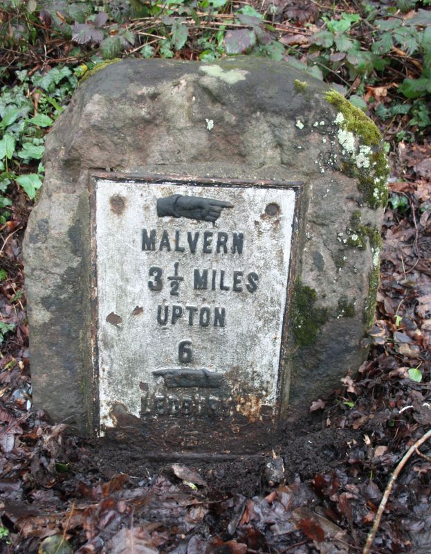
LITTLE MALVERN CP A 449
SO 74 SE
2/156 Milestone
II
Milestone. Mid-C19. Sandstone with cast iron plate. Rectangular plan.
Plate has raised letters and pointing fingers. Inscribed: "Malvern 3½ Miles.
Upton 6".
Listing NGR: SO7677040441
External links are from the relevant listing authority and, where applicable, Wikidata. Wikidata IDs may be related buildings as well as this specific building. If you want to add or update a link, you will need to do so by editing the Wikidata entry.


Other nearby listed buildings
