Approximate Location Map
Large Map »
Latitude: 51.9149 / 51°54'53"N
Longitude: -2.5975 / 2°35'51"W
OS Eastings: 358997
OS Northings: 224214
OS Grid: SO589242
Mapcode National: GBR FR.PD9L
Mapcode Global: VH86H.X4NB
Plus Code: 9C3VWC72+XX
Entry Name: Wilton Bridge (That Part in Ross on Wye Urban District)
Listing Date: 22 October 1952
Grade: I
Source: Historic England
Source ID: 1349266
English Heritage Legacy ID: 153462
ID on this website: 101349266
Location: Wilton, County of Herefordshire, HR9
County: County of Herefordshire
Civil Parish: Ross-on-Wye
Built-Up Area: Wilton
Traditional County: Herefordshire
Lieutenancy Area (Ceremonial County): Herefordshire
Church of England Parish: Bridstow
Church of England Diocese: Hereford
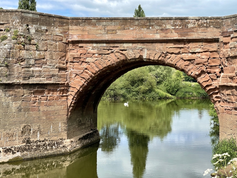
Wilton Bridge
1. (That part in Ross-on-Wye
1560 Urban District)
SO 52 SE 2/87 22.10.52.
I
2,
An exceptionally fine stone bridge. In 1597 an Act was passed authorising
its construction. It was completed within the next 2 years. 5 semi- circular
arches each with 3 ribs. Massive cutwaters on each side carried up and
splayed back from the outer angle at parapet level forming semi-hexagonal
refuges. At the point where the splay dies out is a moulded string which
is mitred and carried up to the angle against the spandrils of the arches
and then mitred and carried across to form a label above the arches. The
voussoirs of the arches are chamfered and joggled and have various masons'
marks. On upstream side the bridge has been widened but now the parapet
has gone and been replaced by a wooden handrail. South East approach to
bridge has been rebuilt in ashlar with 2 flights of stone steps to the river
bank. The sundial, formerly in one of the refuges has gone and only the
base of the pedestal remains. Part listed in Ross and Whitchurch Rural
District. RCHM.
Listing NGR: SO5899724214
External links are from the relevant listing authority and, where applicable, Wikidata. Wikidata IDs may be related buildings as well as this specific building. If you want to add or update a link, you will need to do so by editing the Wikidata entry.


Other nearby listed buildings
