Approximate Location Map
Large Map »
Latitude: 52.0817 / 52°4'54"N
Longitude: -3.1199 / 3°7'11"W
OS Eastings: 323350
OS Northings: 243183
OS Grid: SO233431
Mapcode National: GBR F1.C2PZ
Mapcode Global: VH6BB.VYZ2
Plus Code: 9C4R3VJJ+M2
Entry Name: Lower Moor Lodge
Listing Date: 16 November 1984
Grade: II
Source: Historic England
Source ID: 1168003
English Heritage Legacy ID: 153727
ID on this website: 101168003
Location: County of Herefordshire, HR3
County: County of Herefordshire
Civil Parish: Cusop
Traditional County: Herefordshire
Lieutenancy Area (Ceremonial County): Herefordshire
Church of England Parish: Cusop
Church of England Diocese: Hereford
Tagged with: Gatehouse
SO 24 SW CUSOP CP A 438 (east side)
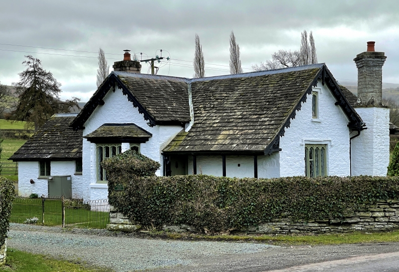
4/106 Lower Moor Lodge
II
Lodge. Mid-C19. Painted rubble, stone slate roof. One storey and attic.
T-plan, stem slightly off-centre left; Tudor Gothic. Gabled wing projects
in centre, external stack to right with diamond shaft, to left rustic
verandah under cat-slide roof along side of projecting wing, door to rear;
gable of projecting wing has shaped barge boards, attic lit by single
Tudor-arched casement under square label, to ground floor a window of 5
trefoiled lights under square label. Lodge to The Moor, Clifford (now
demolished).
Listing NGR: SO2335043183
External links are from the relevant listing authority and, where applicable, Wikidata. Wikidata IDs may be related buildings as well as this specific building. If you want to add or update a link, you will need to do so by editing the Wikidata entry.


Other nearby listed buildings
