Approximate Location Map
Large Map »
Latitude: 52.0781 / 52°4'41"N
Longitude: -3.1234 / 3°7'24"W
OS Eastings: 323109
OS Northings: 242791
OS Grid: SO231427
Mapcode National: GBR F1.C7VJ
Mapcode Global: VH6BJ.T157
Plus Code: 9C4R3VHG+6M
Entry Name: Coopers Hall
Listing Date: 16 November 1984
Grade: II
Source: Historic England
Source ID: 1099511
English Heritage Legacy ID: 153728
ID on this website: 101099511
Location: County of Herefordshire, HR3
County: County of Herefordshire
Civil Parish: Cusop
Built-Up Area: Hay-on-Wye
Traditional County: Herefordshire
Lieutenancy Area (Ceremonial County): Herefordshire
Church of England Parish: Cusop
Church of England Diocese: Hereford
Tagged with: Building
SO 24 SW CUSOP CP A 438 (off east side)
Hay on Wye
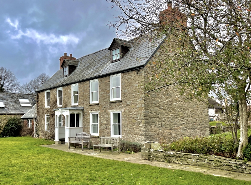
4/107 Cooper's Hall
II
Farmhouse. Mid-C18, with mid-C19 and C20 alterations. Rubble, slate roof.
Three room plan, central staircase. Two storeys and attic lit by 2 gabled
dormers; 5 flush plate glass sashes, mid-C19; ground floor: central entrance
flanked by 4 plate glass sashes, under wedge lintels; central wooden porch of
mid-C19 with shallow pitched roof and segmental headed opening; door of 6
panels, middle 2 glazed. Rear elevation: stair light with ogee head and
Gothick glazing. Interior: open stair well, ramped hand rail, open string,
turned balusters.
Listing NGR: SO2310942791
External links are from the relevant listing authority and, where applicable, Wikidata. Wikidata IDs may be related buildings as well as this specific building. If you want to add or update a link, you will need to do so by editing the Wikidata entry.


Other nearby listed buildings
