Approximate Location Map
Large Map »
Latitude: 52.3136 / 52°18'48"N
Longitude: -2.0673 / 2°4'2"W
OS Eastings: 395508
OS Northings: 268387
OS Grid: SO955683
Mapcode National: GBR 2G4.S79
Mapcode Global: VH9ZS.33YR
Plus Code: 9C4V8W7M+C3
Entry Name: Tan House Farmhouse
Listing Date: 22 July 1981
Grade: II
Source: Historic England
Source ID: 1167715
English Heritage Legacy ID: 156151
ID on this website: 101167715
Location: Stoke Heath, Bromsgrove, Worcestershire, B60
County: Worcestershire
District: Bromsgrove
Civil Parish: Stoke
Built-Up Area: Bromsgrove
Traditional County: Worcestershire
Lieutenancy Area (Ceremonial County): Worcestershire
Church of England Parish: Stoke Prior, Wychbold and Upton Warren
Church of England Diocese: Worcester
Tagged with: Farmhouse
SO 95 68 STOKE PRIOR CP BUNTSFORD HILL (south side)
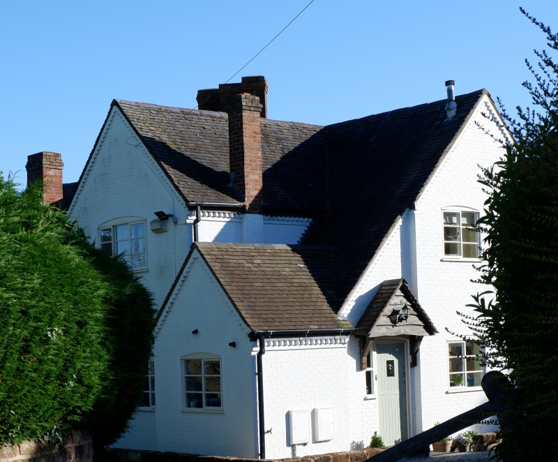
17/100 Tan House Farmhouse
22.7.81
GV II
Farmhouse. 1631, extended early C19 with late C20 extensions and restoration.
Timber-frame with rendered infill and painted brick, tile roof. Two parallel
ranges aligned north-west/south-east; the front (north-west) range added in
early C19. Stack placed laterally on C17 range with four re-built diamond-
plan shafts: Street (north-west) front: two storeys with dog-tooth brick
cornice, to right short projecting C20 gabled wing; three windows: 2-light
casement to left, gabled dormer in cat-slide roof over porch and a 3-light
casement to right; ground floor: entrance in angle under cat-slide roof has
a C20 ledged and boarded door. Framing: close-studding with straight tension
braces to both floors; north-east gable has jettied tie-beam inscribed:
"WS FS 1631": [A L Cummings, The Framed House of Massachusetts Bay 1625-1725,
1979, fig 137 (p 109)]:
Listing NGR: SO9550868387
External links are from the relevant listing authority and, where applicable, Wikidata. Wikidata IDs may be related buildings as well as this specific building. If you want to add or update a link, you will need to do so by editing the Wikidata entry.


Other nearby listed buildings
