Approximate Location Map
Large Map »
Latitude: 52.338 / 52°20'16"N
Longitude: -1.9914 / 1°59'29"W
OS Eastings: 400681
OS Northings: 271107
OS Grid: SP006711
Mapcode National: GBR 2G1.FC0
Mapcode Global: VH9ZM.FHLH
Plus Code: 9C4W82Q5+6C
Entry Name: Cattespool
Listing Date: 23 April 1952
Last Amended: 16 July 1986
Grade: II*
Source: Historic England
Source ID: 1168031
English Heritage Legacy ID: 156228
ID on this website: 101168031
Location: Bromsgrove, Worcestershire, B60
County: Worcestershire
District: Bromsgrove
Civil Parish: Tutnall and Cobley
Traditional County: Worcestershire
Lieutenancy Area (Ceremonial County): Worcestershire
Church of England Parish: Tardebigge
Church of England Diocese: Worcester
Tagged with: Building
SP 07 SW TUTNALL & COBLEY CP STONEY LANE (north side)
6/176 Cattespool
(Formerly listed as Cattespool
23.4.52 Farmhouse)
GV II*
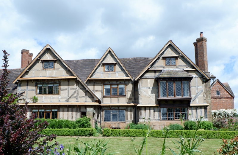
House. c1640, extended late C17 with some late C20 restoration. Timber-
frame with rendered infill on sandstone plinth, extended in ashlar with
tile roof. H-plan, lateral stack to hall range (aligned east/west), through-
passage to west end. South front: two storeys, with attics to wings lit by
2-light casements; first floor: three windows: 4-light and 3-light casements,
4-light square oriel to right; ground floor: mainly 4-light casements,
entrance to left of hall range through lean-to timber-framed porch with
C17 door; ashlar extension to left is of one storey with attic lit by a
gabled dormer. Framing: unpainted, three square panels high with straight
tension braces to first floor, close-studding to ground floor. Interior:
numerous exposed ceiling beams chamfered and stopped; fireplaces with stone
lintels; a number of windows retain C17 sliding shutters. It is very
unusual in this area for a house such as this to have retained the untreated
texture of the framing. (BoE, p 277; Stephen Price, "Standing Buildings in the
Alvechurch Area", Worcestershire Archaeology and Local History Newsletter,
no 31, 1983, pp 21 - 22).
Listing NGR: SP0068171107
External links are from the relevant listing authority and, where applicable, Wikidata. Wikidata IDs may be related buildings as well as this specific building. If you want to add or update a link, you will need to do so by editing the Wikidata entry.


Other nearby listed buildings
