Approximate Location Map
Large Map »
Latitude: 52.319 / 52°19'8"N
Longitude: -2.0832 / 2°4'59"W
OS Eastings: 394428
OS Northings: 268986
OS Grid: SO944689
Mapcode National: GBR 2G3.N4F
Mapcode Global: VH923.VZ25
Plus Code: 9C4V8W98+HP
Entry Name: Barn About 20 Yards North-East of Bowling Green Farmhouse
Listing Date: 17 July 1986
Grade: II
Source: Historic England
Source ID: 1100103
English Heritage Legacy ID: 156377
ID on this website: 101100103
Location: Stoke Heath, Bromsgrove, Worcestershire, B61
County: Worcestershire
District: Bromsgrove
Civil Parish: Stoke
Built-Up Area: Stoke Prior
Traditional County: Worcestershire
Lieutenancy Area (Ceremonial County): Worcestershire
Tagged with: Barn
SO 96 NW DODFORD WITH GRAFTON CP WORCESTER ROAD (west side)
11/114 Barn about 20 yards
north-east of
Bowling Green Farmhouse
GV II
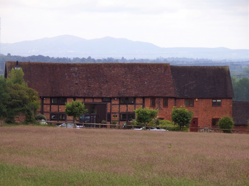
Barn. C17 with early C19 alterations and additions. Part timber-framed with
brick infill on brick base, brick replacement walling with blue brick dressings,
some tile-hanging at east end; plain tiled roof. Seven bays aligned roughly
east/west; wagon bay situated in third bay from east end and has opposed cart
entries with double doors to north elevation, bricked in to south elevation.
Partly two levels. Diaper ventilation patterns. Framing exposed in two east
bays, north elevation and at west gable end; four rows of panels from sill to
wall-plate-with some lower corner braces; collar and tie-beam truss with two
collars and four struts to lower collar, two to upper collar at west end.
South elevation: openings all have cambered heads; three windows, three
doors and a loft opening. Interior: roof has queen post trusses with lower
raking struts and two tiers of purlins. This large barn occupies a prominent
situation adjacent to Bowling Green Farmhouse (qv). Included for group value.
Listing NGR: SO9442868986
External links are from the relevant listing authority and, where applicable, Wikidata. Wikidata IDs may be related buildings as well as this specific building. If you want to add or update a link, you will need to do so by editing the Wikidata entry.


Other nearby listed buildings
