Approximate Location Map
Large Map »
Latitude: 52.3758 / 52°22'32"N
Longitude: -2.316 / 2°18'57"W
OS Eastings: 378583
OS Northings: 275348
OS Grid: SO785753
Mapcode National: GBR 0BK.37V
Mapcode Global: VH91S.SKZ3
Plus Code: 9C4V9MGM+8H
Entry Name: 59 and 60, Load Street
Listing Date: 2 October 1975
Grade: II
Source: Historic England
Source ID: 1348269
English Heritage Legacy ID: 156767
ID on this website: 101348269
Location: Bewdley, Wyre Forest, Worcestershire, DY12
County: Worcestershire
District: Wyre Forest
Civil Parish: Bewdley
Built-Up Area: Bewdley
Traditional County: Worcestershire
Lieutenancy Area (Ceremonial County): Worcestershire
Church of England Parish: Ribbesford with Bewdley and Dowles etc
Church of England Diocese: Worcester
Tagged with: Building
SO 7875 SE BEWDLEY CP LOAD STREET (north side)
13/123 Nos 59 and 60
2.10.75
GV II
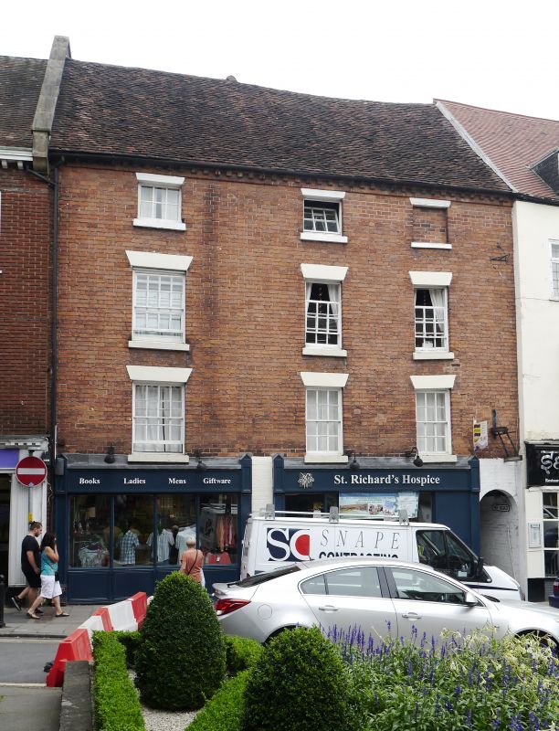
Probably two houses, now two shops, house and flats. Probably early C17,
refronted mid-C18 with mid-C19 and some mid-C20 alterations. Timber-frame
clad in brick with tile roof. No 60 has the shops on the street front,
with a passage at the right-hand corner called "No Road", leading to no 59
Load Street which is attached to the rear of no 60. Four storeys, dentilled
brick cornice, three windows: 16-pane sash to left, and two glazing bar
sashes with stone sills and plastered wedge lintels; second floor: as first
floor; third floor; two single-light casements to left, then a boarded door
and lastly to right a blind window; ground floor: two shop fronts, to left
C20 is pilastered with shallow bow window, half-glazed door to right; shop
front to right larger, C19, has pilasters with scroll brackets to blind
box, central half-glazed door flanked by multi-pane shop windows; to
right-hand corner entrance to "No Road". Rear wall of no 60 has band to
first flor, dog tooth band to second floor which also has a square label
to a blocked window. A rear wing joins no 60 to no 59, which spans "No
Road", and includes some C17 timber-framing. Framing of no 60 visible in
passageway, including evidence for first floor jetty.
Listing NGR: SO7858375348
External links are from the relevant listing authority and, where applicable, Wikidata. Wikidata IDs may be related buildings as well as this specific building. If you want to add or update a link, you will need to do so by editing the Wikidata entry.


Other nearby listed buildings
