Approximate Location Map
Large Map »
Latitude: 52.3758 / 52°22'33"N
Longitude: -2.3113 / 2°18'40"W
OS Eastings: 378903
OS Northings: 275356
OS Grid: SO789753
Mapcode National: GBR 0BK.4GD
Mapcode Global: VH91S.WKG1
Plus Code: 9C4V9MGQ+8F
Entry Name: 5, 7 and 9, Stourport Road
Listing Date: 24 March 1970
Grade: II*
Source: Historic England
Source ID: 1167365
English Heritage Legacy ID: 156881
ID on this website: 101167365
Location: Bewdley, Wyre Forest, Worcestershire, DY12
County: Worcestershire
District: Wyre Forest
Civil Parish: Bewdley
Built-Up Area: Bewdley
Traditional County: Worcestershire
Lieutenancy Area (Ceremonial County): Worcestershire
Church of England Parish: Wribbenhall
Church of England Diocese: Worcester
Tagged with: Building
SO 7875 SE BEWDLEY CP STOURPORT ROAD (north side)
Wribbenhall
13/231 Nos 5, 7 and 9
24.3.70
GV II*
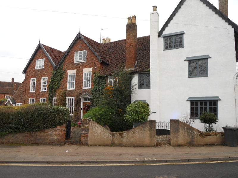
House, now three houses and shop. C14, remodelled early C18 with mid-C19
and some mid-C20 alterations. Timber-frame clad in brick, partially
rendered, with tile roof. T-plan, cross-wing at east end; the hall was a
two-bay open hall with spere and screens at east end, cross-wing at lower
end, with a single bay in line with hall at upper end. South front: two
gables to left, cross-wing to right, two storeys with attic lit by windows
in gables; no 5 to left: two windows: glazing bar sashes under rubbed brick
heads, same on ground floor, lean-to against left-hand wall with entrance
which has a gabled wooden canopy on wooden brackets with a half-glazed C20
door; no 7: three windows: two boxed glazing bar sashes under painted wedge
lintels, to right a 2-light casement; ground floor: three boxed glazing bar
sashes, roughly central entrance has a plain wooden architrave, triangular
wooden canopy, 2-pane overlight and four panel door; no 9 to right rendered,
two windows: 2-light casements, ground floor: 3-light casement to right,
new entrance to left-hand side (old entrance blocked immediately to right)
has a plain wooden architrave and C20 glazed door. Framing: central truss
of hall is a base cruck visible in attic which has an aisle-plate clasped
between the top of the curved members and the cambered tie-beam, which has
cusped arch-braces below; the upper roof has a crown-post supported by
concave braces, crown-plate below collar; scissor-braces parallel to common
rafters are halved over the collar. The cross-wing (no 9) is reported to
have a two-bay crown post roof of similar construction. (S Price, 1974,
"Bewdley Buildings", Worcestershire Archaeology and Local History Newsletter,
no 14, p 9: S Davies & S Price, 1975, Bewdley Buildings Survey: 5 - 7 Stourport
Road, Wribbenhall", Worcestershire Archaeology and Local History Newsletter,
no 16, p 10; Measured sketches in files of Local History Department, Birmingham
City Museums and Art Gallery).
Listing NGR: SO7889875363
External links are from the relevant listing authority and, where applicable, Wikidata. Wikidata IDs may be related buildings as well as this specific building. If you want to add or update a link, you will need to do so by editing the Wikidata entry.


Other nearby listed buildings
