Approximate Location Map
Large Map »
Latitude: 52.3723 / 52°22'20"N
Longitude: -2.2051 / 2°12'18"W
OS Eastings: 386132
OS Northings: 274942
OS Grid: SO861749
Mapcode National: GBR 1D1.7B4
Mapcode Global: VH91V.QMLQ
Plus Code: 9C4V9QCV+WX
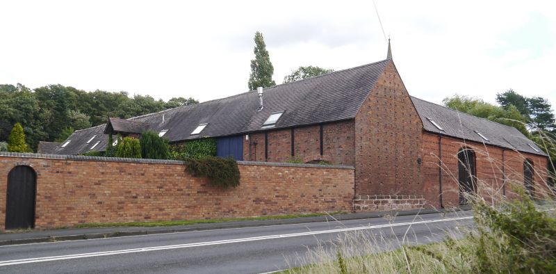
Entry Name: Barn About 30 Metres South-West of Stone Court
Listing Date: 18 March 1987
Grade: II
Source: Historic England
Source ID: 1100664
English Heritage Legacy ID: 157103
ID on this website: 101100664
Location: Stone, Wyre Forest, Worcestershire, DY10
County: Worcestershire
District: Wyre Forest
Civil Parish: Stone
Traditional County: Worcestershire
Lieutenancy Area (Ceremonial County): Worcestershire
Church of England Parish: Kidderminster East
Church of England Diocese: Worcester
Tagged with: Barn
STONE CP STONE HILL (north side)
SO 87 SE
10/113 Barn about 30 metres
south-west of
Stone Court
GV II
Barn. Early C19. Brick with machine tile roof. Probably seven roof bays
with two threshing floors, dog tooth brick cornice, and hit-and-miss
ventilators. Included for group value.
Listing NGR: SO8613274942
External links are from the relevant listing authority and, where applicable, Wikidata. Wikidata IDs may be related buildings as well as this specific building. If you want to add or update a link, you will need to do so by editing the Wikidata entry.


Other nearby listed buildings
