Approximate Location Map
Large Map »
Latitude: 51.9893 / 51°59'21"N
Longitude: -0.1881 / 0°11'17"W
OS Eastings: 524514
OS Northings: 233870
OS Grid: TL245338
Mapcode National: GBR J6Y.791
Mapcode Global: VHGNM.P8F9
Plus Code: 9C3XXRQ6+PQ
Entry Name: Halford House
Listing Date: 8 November 1949
Grade: II*
Source: Historic England
Source ID: 1102099
English Heritage Legacy ID: 161629
ID on this website: 101102099
Location: Baldock, North Hertfordshire, SG7
County: Hertfordshire
District: North Hertfordshire
Electoral Ward/Division: Baldock Town
Parish: Non Civil Parish
Built-Up Area: Baldock
Traditional County: Hertfordshire
Lieutenancy Area (Ceremonial County): Hertfordshire
Church of England Parish: Baldock
Church of England Diocese: St.Albans
Tagged with: House
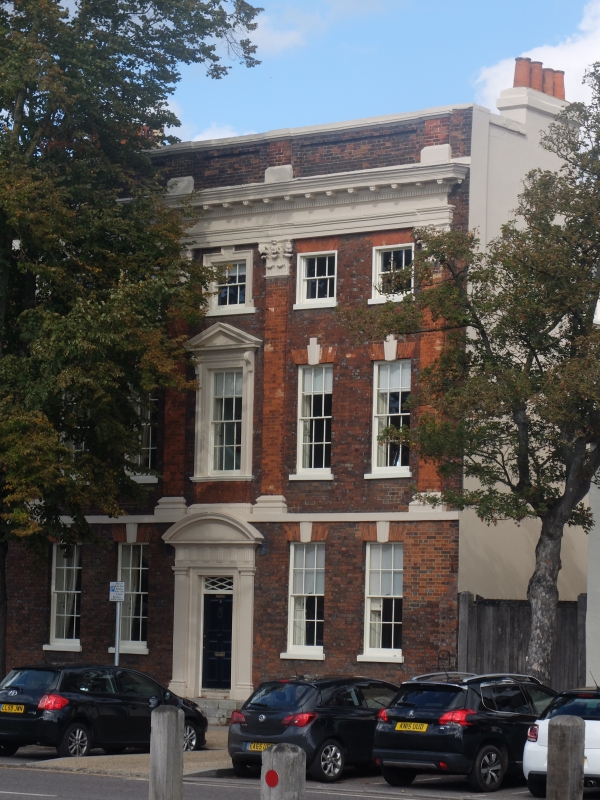
HIGH STREET
1. (North East Side)
5255 -----------------
No 9 (Halford House)
TL 2433 NE 2/8 8.ll.9.
II* GV
2.
C18 house of deep red brick dressed with lighter red. Main block with
slightly recessed wing on left, 1:5 sash windows with glazing bars under
flat arches. 3 storeys, first floor stucco band serves as pediment for
4 brick pilasters with carved Corinthian capitals, painted (?stone) beneath
stone entablature with eaves level modillioned anddenticulated cornice.
Panelled parapet masks roof. Four stone steps up to 6 fielded panelled
doer and rectangular fanlight with diagonal glazing bars in shallow reveal,
architrave surround, Doric pilasters, entablature with triglyphs, segmental
pediment. Second floor central window has stone architrave surround with
taller keystone. First floor central window has architrave surround,
pediment on consoles. Ground and first floor side pairs of windows have
triple keystones. Brick plinth with 4 small cellar windows.
Nos 1 to 11 (odd) 15, 19, 21, outbuilding east of No 21, 23, 23A, 25, 29
33, 35A, 37, 37B, 41A, 41B, 41, 43, 45, and 53 to 63 (odd) form a group.
Listing NGR: TL2451433870
External links are from the relevant listing authority and, where applicable, Wikidata. Wikidata IDs may be related buildings as well as this specific building. If you want to add or update a link, you will need to do so by editing the Wikidata entry.


Other nearby listed buildings
