Approximate Location Map
Large Map »
Latitude: 51.8139 / 51°48'50"N
Longitude: -0.297 / 0°17'49"W
OS Eastings: 517491
OS Northings: 214182
OS Grid: TL174141
Mapcode National: GBR H7L.9Q4
Mapcode Global: VHGPB.SNVT
Plus Code: 9C3XRP73+H5
Entry Name: Bury Farm Cottages
Listing Date: 11 December 1973
Last Amended: 24 October 1995
Grade: II
Source: Historic England
Source ID: 1347257
English Heritage Legacy ID: 163920
ID on this website: 101347257
Location: Wheathampstead, St. Albans, Hertfordshire, AL4
County: Hertfordshire
District: St. Albans
Civil Parish: Wheathampstead
Built-Up Area: Wheathampstead
Traditional County: Hertfordshire
Lieutenancy Area (Ceremonial County): Hertfordshire
Church of England Parish: Wheathampstead
Church of England Diocese: St.Albans
Tagged with: Cottage
TL 1714
270/14/375
11.12.73
WHEATHAMPSTEAD
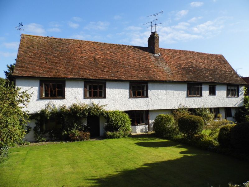
Bury Farm Cottages
II
Cottage range, formerly part of manorial farm complex. C16 or earlier, with C19 and C20 alterations and additions. Timber-framed structure, now roughcast, the upper floor jettied to both front and rear. Plain clay tile roof covering, with central brick ridge chimney stack, and rear wall stack at north end. 2 storeys, 6 bays with mostly 3-light C19 casements with moulded frames. At east end, ground floor 3-light timber mullioned window of C16 date. This has hollow-moulded 4-centre arch heads to lights, and leaded casements. Plainer 3-light wooden mullioned window to first floor. Rear elevation with exposed close studding to first floor above C20 extension and central offshoot beneath extended roof slope. INTERIOR: common rafter roof, with curved wind bracing to purlins. Much exposed framing and partitioning, including original framed door opening and (now) interior 3-light mullioned window with arched heads. HISTORY: This building appears to have formed part of a manorial complex in the ownership of Westminster Abbey. Previous functions included farmhouse and later, labourers cottages. Recent research has likened the linear form of the originally unheated range to that of a guildhall or church house, but serving a different function in such a rural location. ( Smith. J.T. `English Houses 1200-1800- The Hertfordshire Evidence', p148. R.C.H.M.E. 1994. )
Listing NGR: TL1749114182
External links are from the relevant listing authority and, where applicable, Wikidata. Wikidata IDs may be related buildings as well as this specific building. If you want to add or update a link, you will need to do so by editing the Wikidata entry.


Other nearby listed buildings
