Approximate Location Map
Large Map »
Latitude: 51.8274 / 51°49'38"N
Longitude: -0.2943 / 0°17'39"W
OS Eastings: 517644
OS Northings: 215687
OS Grid: TL176156
Mapcode National: GBR H7D.JD2
Mapcode Global: VHGPB.VB9F
Plus Code: 9C3XRPG4+X7
Entry Name: Whippletrees
Listing Date: 27 September 1984
Grade: II
Source: Historic England
Source ID: 1103666
English Heritage Legacy ID: 164000
ID on this website: 101103666
Location: Gustard Wood, St. Albans, Hertfordshire, AL4
County: Hertfordshire
District: St. Albans
Civil Parish: Wheathampstead
Traditional County: Hertfordshire
Lieutenancy Area (Ceremonial County): Hertfordshire
Church of England Parish: Wheathampstead
Church of England Diocese: St.Albans
Tagged with: Building
TL 11 NE WHEATHAMPSTEAD LAMER LANE
(west side)
GUSTARDWOOD
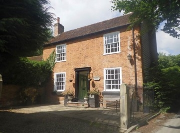
3/451 Whippletrees
GV II
House. Circa 1840. Red brick. Plain tile gable end roof with
internal stuccoed stack on left end. 2 storeys. 2 original
flush sash windows with moulded frames. Gauged brick lintels.
Moulded panel door in modern frame.
Listing NGR: TL1764415687
External links are from the relevant listing authority and, where applicable, Wikidata. Wikidata IDs may be related buildings as well as this specific building. If you want to add or update a link, you will need to do so by editing the Wikidata entry.


Other nearby listed buildings
